
Topografische kaart Dihlabeng Ward 20
Interactieve kaart
Klik op de kaart om de hoogte weer te geven.
Over deze kaart
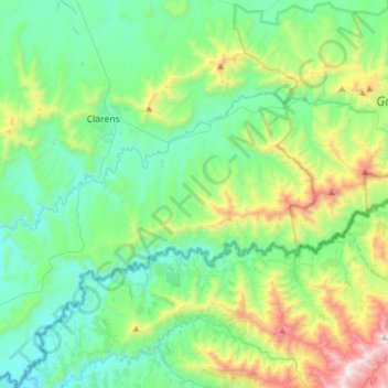
Naam: Topografische kaart Dihlabeng Ward 20, hoogte, reliëf.
Gemiddelde hoogte: 1.975 m
Minimale hoogte: 1.615 m
Maximale hoogte: 3.100 m
Andere topografische kaarten
Klik op een kaart om zijn topografie, zijn hoogte en zijn reliëf te bekijken.
Swartkrans
RSA > Free State > Dihlabeng Local Municipality
Swartkrans, Dihlabeng Local Municipality, Thabo Mofutsanyana District Municipality, Free State, RSA
Gemiddelde hoogte: 2.036 m
Golden Gate Highlands National Park
RSA > Free State > Dihlabeng Local Municipality
Golden Gate Highlands National Park, Blesbok Loop, Dihlabeng Ward 20, Dihlabeng Local Municipality, Thabo Mofutsanyana District Municipality, Free State, RSA
Gemiddelde hoogte: 2.065 m