
Topografische kaart Edingale
Klik op de kaart om de hoogte weer te geven.
Over deze kaart
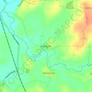
Naam: Topografische kaart Edingale, hoogte, reliëf.
Gemiddelde hoogte: 63 m
Minimale hoogte: 47 m
Maximale hoogte: 90 m
Andere topografische kaarten
Klik op een kaart om zijn topografie, zijn hoogte en zijn reliëf te bekijken.
Whittington
United Kingdom > England > Staffordshire > Lichfield > Whittington
Gemiddelde hoogte: 70 m
Mavesyn Ridware
United Kingdom > England > Staffordshire > Lichfield > Hill Ridware
Gemiddelde hoogte: 81 m
Chasewater
United Kingdom > England > Staffordshire > Lichfield > Burntwood > Chasetown
Gemiddelde hoogte: 155 m
Gentleshaw Common
United Kingdom > England > Staffordshire > Lichfield > Longdon
Gemiddelde hoogte: 181 m
Fulfen Wood
United Kingdom > England > Staffordshire > Lichfield > Whittington > Streethay
Gemiddelde hoogte: 69 m
Clifton Campville
United Kingdom > England > Staffordshire > Lichfield > Clifton Campville
Gemiddelde hoogte: 77 m