
Topografische kaart Baxter Island
Interactieve kaart
Klik op de kaart om de hoogte weer te geven.
Over deze kaart
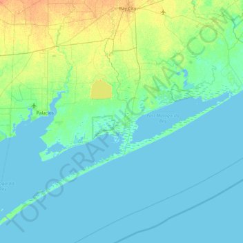
Naam: Topografische kaart Baxter Island, hoogte, reliëf.
Locatie: Baxter Island, Matagorda County, Texas, 77415, United States (28.36360 -96.30746 29.00360 -95.66746)
Gemiddelde hoogte: 4 m
Minimale hoogte: -3 m
Maximale hoogte: 22 m
Andere topografische kaarten
Klik op een kaart om zijn topografie, zijn hoogte en zijn reliëf te bekijken.
Matagorda County
United States > Texas > Matagorda County
Matagorda County, Texas, United States
Gemiddelde hoogte: 8 m
Ashwood
United States > Texas > Matagorda County > Ashwood
Ashwood, Matagorda County, Texas, United States
Gemiddelde hoogte: 16 m