
Topografische kaart Solferino
Interactieve kaart
Klik op de kaart om de hoogte weer te geven.
Over deze kaart
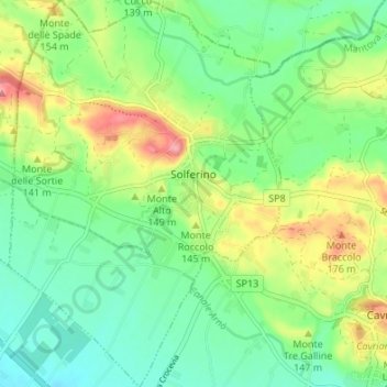
Naam: Topografische kaart Solferino, hoogte, reliëf.
Locatie: Solferino, Mantua, Lombardy, 46040, Italy (45.34248 10.53443 45.38982 10.58191)
Gemiddelde hoogte: 119 m
Minimale hoogte: 77 m
Maximale hoogte: 198 m
The municipal territory, extending for 13.08 km2, is part of the Morainic amphitheatre of Lake Garda, located a few kilometres to the north. The altitude at the town hall is 124 m above sea level. Not far away also lies the province of Verona, with the towns of Peschiera del Garda and Valeggio sul Mincio, only a few kilometres to the east.
Andere topografische kaarten
Klik op een kaart om zijn topografie, zijn hoogte en zijn reliëf te bekijken.
Volta Mantovana
Italy > Lombardy > Mantua > Volta Mantovana
Volta Mantovana, Mantua, Lombardy, Italy
Gemiddelde hoogte: 73 m
Castiglione delle Stiviere
Italy > Lombardy > Mantua > Castiglione delle Stiviere > Castiglione delle Stiviere
Castiglione delle Stiviere, Mantua, Lombardy, 46043, Italy
Gemiddelde hoogte: 107 m
Sabbioneta
Italy > Lombardy > Mantua > Sabbioneta
Sabbioneta, Mantua, Lombardy, 46018, Italy
Gemiddelde hoogte: 23 m