
Doe een donatie
Rust jezelf uit voor je volgende avontuur:
Als Amazon-partner verdient deze site een commissie op in aanmerking komende aankopen, zonder extra kosten voor jou.
Topografische kaart Safford
Klik op de kaart om de hoogte weer te geven.
Doe een donatie
Rust jezelf uit voor je volgende avontuur:
Als Amazon-partner verdient deze site een commissie op in aanmerking komende aankopen, zonder extra kosten voor jou.
Safford
The climate is hot semi-arid (Köppen: BSh) softened by the plateau rise (it receives enough rainfall not to fall into a hot desert, BWh). It is much hotter than most places in eastern Arizona due to its relatively low elevation of 2,953 feet (900 m) at the Agricultural Center where records are kept, and often reaches temperatures almost as hot as found in Phoenix. In January, the average high temperature is 60 °F or 15.6 °C with a low of 29 °F or −1.7 °C. In July, the average high temperature is 98 °F or 36.7 °C with a low of 68 °F or 20 °C. Annual precipitation averages around 9.8 inches (248.9 mm), and snowfall is exceptionally rare: the mean is around 0.8 inches (0.020 m) but the median is zero.
Doe een donatie
Rust jezelf uit voor je volgende avontuur:
Als Amazon-partner verdient deze site een commissie op in aanmerking komende aankopen, zonder extra kosten voor jou.
Over deze kaart
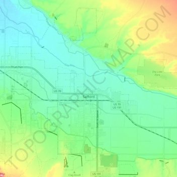
Naam: Topografische kaart Safford, hoogte, reliëf.
Locatie: Safford, Graham County, Arizona, 85546, United States (32.79375 -109.73981 32.88137 -109.62618)
Gemiddelde hoogte: 911 m
Minimale hoogte: 868 m
Maximale hoogte: 1.012 m
Doe een donatie
Rust jezelf uit voor je volgende avontuur:
Als Amazon-partner verdient deze site een commissie op in aanmerking komende aankopen, zonder extra kosten voor jou.
Andere topografische kaarten
Klik op een kaart om zijn topografie, zijn hoogte en zijn reliëf te bekijken.