
Topografische kaart Ozaukee County
Interactieve kaart
Klik op de kaart om de hoogte weer te geven.
Over deze kaart
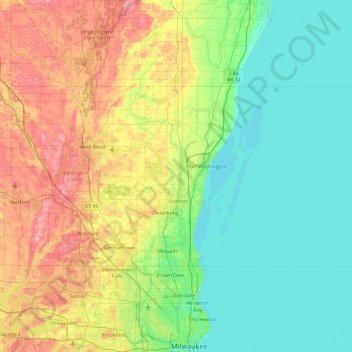
Naam: Topografische kaart Ozaukee County, hoogte, reliëf.
Locatie: Ozaukee County, Wisconsin, United States of America (43.19197 -88.06384 43.54341 -87.11920)
Gemiddelde hoogte: 238 m
Minimale hoogte: 171 m
Maximale hoogte: 405 m
Andere topografische kaarten
Klik op een kaart om zijn topografie, zijn hoogte en zijn reliëf te bekijken.
Door County
United States of America > Wisconsin
Door County, Wisconsin, United States of America
Gemiddelde hoogte: 191 m
Bowens Addition
United States of America > Wisconsin > Madison > Bowens Addition
Bowens Addition, Madison, Dane, Wisconsin, 53706, United States of America
Gemiddelde hoogte: 266 m
Gays Mills
United States of America > Wisconsin > Gays Mills
Gays Mills, Crawford County, Wisconsin, United States of America
Gemiddelde hoogte: 272 m
Waukesha County
United States of America > Wisconsin
Waukesha County, Wisconsin, United States of America
Gemiddelde hoogte: 272 m
City of Middleton
United States of America > Wisconsin > City of Middleton
City of Middleton, Dane County, Wisconsin, 53562, United States of America
Gemiddelde hoogte: 290 m
Dodgeville
United States of America > Wisconsin > Dodgeville > Dodgeville
Dodgeville, Wisconsin, United States of America
Gemiddelde hoogte: 369 m
Cedarburg
United States of America > Wisconsin > Cedarburg > Cedarburg
Cedarburg, Ozaukee County, Wisconsin, 53012, United States of America
Gemiddelde hoogte: 247 m
Kenosha County
United States of America > Wisconsin
Kenosha County, Wisconsin, United States of America
Gemiddelde hoogte: 229 m