
Doe een donatie
Rust jezelf uit voor je volgende avontuur:
Als Amazon-partner verdient deze site een commissie op in aanmerking komende aankopen, zonder extra kosten voor jou.
Topografische kaart Minnis Bay
Klik op de kaart om de hoogte weer te geven.
Doe een donatie
Rust jezelf uit voor je volgende avontuur:
Als Amazon-partner verdient deze site een commissie op in aanmerking komende aankopen, zonder extra kosten voor jou.
Over deze kaart
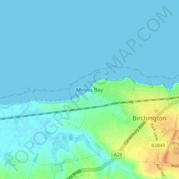
Naam: Topografische kaart Minnis Bay, hoogte, reliëf.
Locatie: Minnis Bay, Thanet, Kent, England, CT7 9QR, United Kingdom (51.36020 1.26560 51.40020 1.30560)
Gemiddelde hoogte: 6 m
Minimale hoogte: -1 m
Maximale hoogte: 36 m
Doe een donatie
Rust jezelf uit voor je volgende avontuur:
Als Amazon-partner verdient deze site een commissie op in aanmerking komende aankopen, zonder extra kosten voor jou.
Andere topografische kaarten
Klik op een kaart om zijn topografie, zijn hoogte en zijn reliëf te bekijken.
Ramsgate
United Kingdom > England > Kent > Thanet
In 2017 Ramsgate was chosen as one of the first ten Heritage Action Zones (HAZ) by Historic England, with the aim of stimulating economic growth by taking advantage of Ramsgate's historic environment. Part of this project included a Historic Landscape Characterisation Study which assessed and mapped the…
Gemiddelde hoogte: 25 m
Doe een donatie
Rust jezelf uit voor je volgende avontuur:
Als Amazon-partner verdient deze site een commissie op in aanmerking komende aankopen, zonder extra kosten voor jou.
Doe een donatie
Rust jezelf uit voor je volgende avontuur:
Als Amazon-partner verdient deze site een commissie op in aanmerking komende aankopen, zonder extra kosten voor jou.
Ramsgate
United Kingdom > England > Kent > Thanet
In 2017 Ramsgate was chosen as one of the first ten Heritage Action Zones (HAZ) by Historic England, with the aim of stimulating economic growth using Ramsgate's historic environment as a catalyst. Part of this project included a Historic Landscape Characterisation Study which assessed and mapped the patterns…
Gemiddelde hoogte: 25 m