
Topografische kaart Chubbuck
Interactieve kaart
Klik op de kaart om de hoogte weer te geven.
Over deze kaart
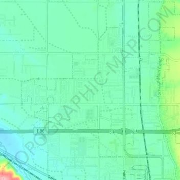
Naam: Topografische kaart Chubbuck, hoogte, reliëf.
Locatie: Chubbuck, Bannock County, Idaho, 83202, United States (42.90573 -112.50598 42.94954 -112.41312)
Gemiddelde hoogte: 1.377 m
Minimale hoogte: 1.339 m
Maximale hoogte: 1.544 m
Chubbuck is located at 42°55′18″N 112°28′3″W / 42.92167°N 112.46750°W / 42.92167; -112.46750 (42.921648, -112.467416), at an elevation of 4,472 feet (1,363 m) above sea level.
Andere topografische kaarten
Klik op een kaart om zijn topografie, zijn hoogte en zijn reliëf te bekijken.
Pocatello
United States > Idaho > Bannock County
Pocatello, Bannock County, Idaho, United States
Gemiddelde hoogte: 1.580 m
Downey
United States > Idaho > Bannock County
Downey, Bannock County, Idaho, United States
Gemiddelde hoogte: 1.482 m
Fort Hall
United States > Idaho > Bannock County
Fort Hall, Bannock County, Idaho, United States
Gemiddelde hoogte: 1.377 m
Lava Hot Springs
United States > Idaho > Bannock County
Lava Hot Springs, Bannock County, Idaho, 83246, United States
Gemiddelde hoogte: 1.611 m
McCammon
United States > Idaho > Bannock County
McCammon, Bannock County, Idaho, United States
Gemiddelde hoogte: 1.465 m
Inkom
United States > Idaho > Bannock County
Inkom, Bannock County, Idaho, United States
Gemiddelde hoogte: 1.447 m