
Topografische kaart Soil Erosion Lake Dam
Interactieve kaart
Klik op de kaart om de hoogte weer te geven.
Over deze kaart
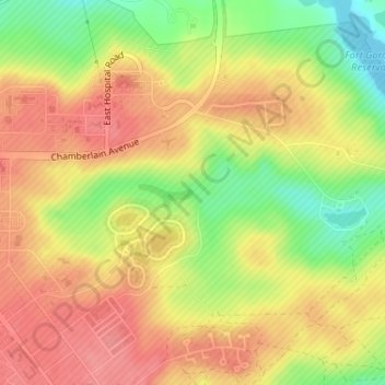
Naam: Topografische kaart Soil Erosion Lake Dam, hoogte, reliëf.
Gemiddelde hoogte: 123 m
Minimale hoogte: 77 m
Maximale hoogte: 153 m
Andere topografische kaarten
Klik op een kaart om zijn topografie, zijn hoogte en zijn reliëf te bekijken.
Bonair
United States > Georgia > Richmond County > Augusta
Bonair, Augusta, Richmond County, Georgia, 30990, United States
Gemiddelde hoogte: 84 m
Bel Air Heights
United States > Georgia > Richmond County > Augusta
Bel Air Heights, Augusta, Richmond County, Georgia, 30905, United States
Gemiddelde hoogte: 118 m
Fort Gordon
United States > Georgia > Richmond County > Augusta
Fort Gordon, Augusta, Richmond County, Georgia, 30905, United States
Gemiddelde hoogte: 136 m
Waverly
United States > Georgia > Richmond County > Augusta
Waverly, Augusta, Richmond County, Georgia, 30909, United States
Gemiddelde hoogte: 96 m
Berckman Villas
United States > Georgia > Richmond County > Augusta
Berckman Villas, Augusta, Richmond County, Georgia, 30904, United States
Gemiddelde hoogte: 87 m
Nixon
United States > Georgia > Richmond County > Augusta
Nixon, Augusta, Richmond County, Georgia, United States
Gemiddelde hoogte: 45 m
Marion Homes
United States > Georgia > Richmond County > Augusta
Marion Homes, Augusta, Richmond County, Georgia, 30901, United States
Gemiddelde hoogte: 44 m
Kennelworth
United States > Georgia > Richmond County > Augusta
Kennelworth, Augusta, Richmond County, Georgia, 30909, United States
Gemiddelde hoogte: 87 m
Windsor Court
United States > Georgia > Richmond County > Augusta
Windsor Court, Augusta, Richmond County, Georgia, 30904, United States
Gemiddelde hoogte: 66 m
Goshen Plantation
United States > Georgia > Richmond County > Augusta > Goshen Plantation
Goshen Plantation, Augusta, Richmond County, Georgia, United States
Gemiddelde hoogte: 73 m
Ridgewood
United States > Georgia > Richmond County > Augusta > Ridgewood
Ridgewood, Augusta, Richmond County, Georgia, 30909, United States
Gemiddelde hoogte: 103 m