
Topografische kaart Platte County
Interactieve kaart
Klik op de kaart om de hoogte weer te geven.
Over deze kaart
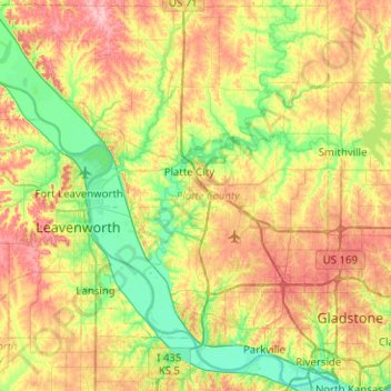
Naam: Topografische kaart Platte County, hoogte, reliëf.
Locatie: Platte County, Missouri, United States of America (39.15309 -95.10334 39.53349 -94.60077)
Gemiddelde hoogte: 276 m
Minimale hoogte: 221 m
Maximale hoogte: 359 m
Andere topografische kaarten
Klik op een kaart om zijn topografie, zijn hoogte en zijn reliëf te bekijken.
Buchanan County
United States of America > Missouri
Buchanan County, Missouri, United States of America
Gemiddelde hoogte: 288 m
Scotsdale
United States of America > Missouri > Scotsdale
Scotsdale, Jefferson County, Missouri, United States of America
Gemiddelde hoogte: 196 m
Cole County
United States of America > Missouri
Cole County, Missouri, United States of America
Gemiddelde hoogte: 219 m
Saint Louis County
United States of America > Missouri
Saint Louis County, Missouri, United States of America
Gemiddelde hoogte: 166 m
Downtown
United States of America > Missouri > Saint Louis
Downtown, Saint Louis, City of Saint Louis, Missouri, United States of America
Gemiddelde hoogte: 138 m