
Topografische kaart McAvoy
Interactieve kaart
Klik op de kaart om de hoogte weer te geven.
Over deze kaart
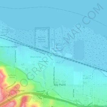
Naam: Topografische kaart McAvoy, hoogte, reliëf.
Gemiddelde hoogte: 20 m
Minimale hoogte: -4 m
Maximale hoogte: 157 m
Andere topografische kaarten
Klik op een kaart om zijn topografie, zijn hoogte en zijn reliëf te bekijken.
Shore Acres
United States > California > Contra Costa County > Bay Point
Shore Acres, Bay Point, Contra Costa County, CAL Fire Northern Region, California, United States
Gemiddelde hoogte: 31 m
Nichols
United States > California > Contra Costa County > Bay Point
Nichols, Bay Point, Contra Costa County, California, United States
Gemiddelde hoogte: 38 m