
Topografische kaart Ingwe Local Municipality
Interactieve kaart
Klik op de kaart om de hoogte weer te geven.
Over deze kaart
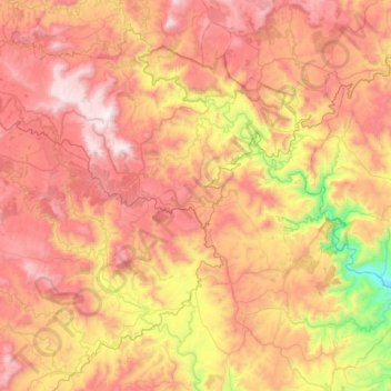
Naam: Topografische kaart Ingwe Local Municipality, hoogte, reliëf.
Gemiddelde hoogte: 1.268 m
Minimale hoogte: 399 m
Maximale hoogte: 2.067 m
Andere topografische kaarten
Klik op een kaart om zijn topografie, zijn hoogte en zijn reliëf te bekijken.
Soada Forest Nature Reserve
RSA > KwaZulu-Natal > Ingwe Local Municipality
Soada Forest Nature Reserve, P8-2, Ingwe Ward 6, Ingwe Local Municipality, Sisonke District Municipality, KwaZulu-Natal, RSA
Gemiddelde hoogte: 881 m