
Topografische kaart Independence
Interactieve kaart
Klik op de kaart om de hoogte weer te geven.
Over deze kaart
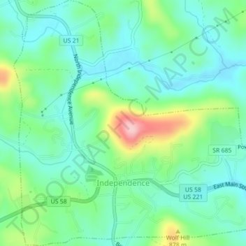
Naam: Topografische kaart Independence, hoogte, reliëf.
Locatie: Independence, Grayson County, Virginia, 24348, United States (36.61515 -81.16653 36.64319 -81.13248)
Gemiddelde hoogte: 817 m
Minimale hoogte: 767 m
Maximale hoogte: 950 m
Andere topografische kaarten
Klik op een kaart om zijn topografie, zijn hoogte en zijn reliëf te bekijken.
Volney
United States > Virginia > Grayson County
Volney, Grayson County, Virginia, 24363, United States
Gemiddelde hoogte: 891 m
Hilltown
United States > Virginia > Grayson County
Hilltown, Grayson County, Virginia, 24330, United States
Gemiddelde hoogte: 727 m
Mouth of Wilson
United States > Virginia > Grayson County
Mouth of Wilson, Grayson County, Virginia, 28663, United States
Gemiddelde hoogte: 798 m
Troutdale
United States > Virginia > Grayson County
Troutdale, Grayson County, Virginia, United States
Gemiddelde hoogte: 999 m
Whitetop
United States > Virginia > Grayson County > Whitetop
Whitetop, Grayson County, Virginia, 24292, United States
Gemiddelde hoogte: 1.107 m
Fries
United States > Virginia > Grayson County
Fries, Grayson County, Virginia, United States
Gemiddelde hoogte: 710 m
Grayson Highlands State Park
United States > Virginia > Grayson County
Grayson Highlands State Park, 829, Grayson County, Virginia, 24363, United States
Gemiddelde hoogte: 1.253 m