
Doe een donatie
Rust jezelf uit voor je volgende avontuur:
Als Amazon-partner verdient deze site een commissie op in aanmerking komende aankopen, zonder extra kosten voor jou.
Topografische kaart Cataldo
Klik op de kaart om de hoogte weer te geven.
Doe een donatie
Rust jezelf uit voor je volgende avontuur:
Als Amazon-partner verdient deze site een commissie op in aanmerking komende aankopen, zonder extra kosten voor jou.
Over deze kaart
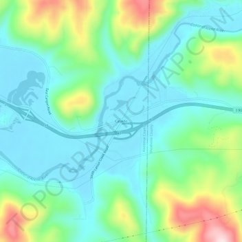
Naam: Topografische kaart Cataldo, hoogte, reliëf.
Locatie: Cataldo, Kootenai County, Idaho, 83839, United States (47.52881 -116.34961 47.56881 -116.30961)
Gemiddelde hoogte: 732 m
Minimale hoogte: 645 m
Maximale hoogte: 970 m
Doe een donatie
Rust jezelf uit voor je volgende avontuur:
Als Amazon-partner verdient deze site een commissie op in aanmerking komende aankopen, zonder extra kosten voor jou.
Andere topografische kaarten
Klik op een kaart om zijn topografie, zijn hoogte en zijn reliëf te bekijken.
Post Falls
United States > Idaho > Kootenai County
Post Falls features a varied and distinctive topography characterized by its placement on the Rathdrum Prairie, which lies at an elevation of approximately 2,182 feet (665 meters) above sea level. This prairie is surrounded by rolling hills and rugged terrain that gradually rise towards the nearby Rocky…
Gemiddelde hoogte: 710 m
Coeur d'Alene
United States > Idaho > Kootenai County
The city is located on the north shore of Lake Coeur d'Alene, near the outlet of the Spokane River, and is in the Northern Rockies ecoregion. Lake Coeur d'Alene is a natural dam-controlled lake that is 25 miles (40 km) long and 1 mile (1.6 km) to 3 miles (4.8 km) wide and fed by the Coeur d'Alene and Saint Joe…
Gemiddelde hoogte: 719 m
Athol
United States > Idaho > Kootenai County
Athol is located at 47°56′46″N 116°42′26″W / 47.94611°N 116.70722°W / 47.94611; -116.70722 (47.946024, -116.707349), at an elevation of 2,392 feet (729 m) above sea level.
Gemiddelde hoogte: 733 m
Doe een donatie
Rust jezelf uit voor je volgende avontuur:
Als Amazon-partner verdient deze site een commissie op in aanmerking komende aankopen, zonder extra kosten voor jou.
Rathdrum
United States > Idaho > Kootenai County
Rathdrum is located on the Rathdrum Prairie at 47°48′30″N 116°53′33″W / 47.80833°N 116.89250°W / 47.80833; -116.89250 (47.808457, -116.892415), at an elevation of 2,211 feet (674 m) above sea level.
Gemiddelde hoogte: 701 m
Spirit Lake
United States > Idaho > Kootenai County
Spirit Lake is located at 47°58′00″N 116°51′59″W / 47.966592°N 116.866383°W / 47.966592; -116.866383, at an elevation of 2,569 feet (783 m) above sea level.
Gemiddelde hoogte: 780 m
Athol
United States > Idaho > Kootenai County
Athol is located at 47°56′46″N 116°42′26″W / 47.94611°N 116.70722°W / 47.94611; -116.70722 (47.946024, -116.707349), at an elevation of 2,392 feet (729 m) above sea level.
Gemiddelde hoogte: 733 m
Doe een donatie
Rust jezelf uit voor je volgende avontuur:
Als Amazon-partner verdient deze site een commissie op in aanmerking komende aankopen, zonder extra kosten voor jou.
Hayden
United States > Idaho > Kootenai County
According to the United States Census Bureau, the city has a total area of 9.61 square miles (24.89 km2), of which 9.60 square miles (24.86 km2) is land and 0.01 square miles (0.03 km2) is water. It lies at the southwestern end of Hayden Lake, and the elevation of the city is 2,287 feet (697 m) above sea level.
Gemiddelde hoogte: 709 m
Post Falls
United States > Idaho > Kootenai County
Post Falls is located on the Rathdrum Prairie, along the Washington–Idaho border. It is bounded by Coeur d’Alene to the east, Stateline and the state of Washington to the west, and the Spokane River to the south. Post Falls is 20 miles (32 km) east of Spokane and approximately 100 miles (160 km) south of…
Gemiddelde hoogte: 710 m
Doe een donatie
Rust jezelf uit voor je volgende avontuur:
Als Amazon-partner verdient deze site een commissie op in aanmerking komende aankopen, zonder extra kosten voor jou.
Coeur d'Alene
United States > Idaho > Kootenai County
The city is located on the north shore of Lake Coeur d'Alene, near the outlet of the Spokane River, and is in the Northern Rockies ecoregion. Lake Coeur d'Alene is a natural dam-controlled lake that is 25 miles (40 km) long and 1 mile (1.6 km) to 3 miles (4.8 km) wide and fed by the Coeur d'Alene and Saint Joe…
Gemiddelde hoogte: 719 m
Doe een donatie
Rust jezelf uit voor je volgende avontuur:
Als Amazon-partner verdient deze site een commissie op in aanmerking komende aankopen, zonder extra kosten voor jou.
Post Falls
United States > Idaho > Kootenai County
Post Falls is located on the Rathdrum Prairie, along the Washington–Idaho border. It is bounded by Coeur d’Alene to the east, Stateline and the state of Washington to the west, and the Spokane River to the south. Post Falls is 20 miles (32 km) east of Spokane and approximately 100 miles (160 km) south of…
Gemiddelde hoogte: 710 m
Rathdrum
United States > Idaho > Kootenai County
Rathdrum is located on the Rathdrum Prairie at 47°48′30″N 116°53′33″W / 47.80833°N 116.89250°W / 47.80833; -116.89250 (47.808457, -116.892415), at an elevation of 2,211 feet (674 m) above sea level.
Gemiddelde hoogte: 701 m