
Topografische kaart Sixteen Mile Creek
Interactieve kaart
Klik op de kaart om de hoogte weer te geven.
Over deze kaart
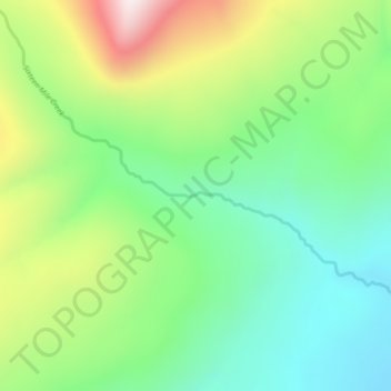
Naam: Topografische kaart Sixteen Mile Creek, hoogte, reliëf.
Gemiddelde hoogte: 1.267 m
Minimale hoogte: 1.027 m
Maximale hoogte: 1.711 m
Andere topografische kaarten
Klik op een kaart om zijn topografie, zijn hoogte en zijn reliëf te bekijken.
Beaver Lake
Canada > British Columbia > Regional District of Kitimat-Stikine > Area F (Dease Lake) > Dease Lake
Beaver Lake, Dease Lake, Area F (Dease Lake), Regional District of Kitimat-Stikine, British Columbia, Canada
Gemiddelde hoogte: 865 m
Dease Lake
Canada > British Columbia > Regional District of Kitimat-Stikine > Area F (Dease Lake)
Dease Lake, Area F (Dease Lake), Regional District of Kitimat-Stikine, British Columbia, V0C 1L0, Canada
Gemiddelde hoogte: 898 m
Ball Creek
Canada > British Columbia > Regional District of Kitimat-Stikine > Area F (Dease Lake)
Ball Creek, Area F (Dease Lake), Regional District of Kitimat-Stikine, British Columbia, Canada
Gemiddelde hoogte: 1.267 m