
Topografische kaart Union
Interactieve kaart
Klik op de kaart om de hoogte weer te geven.
Over deze kaart
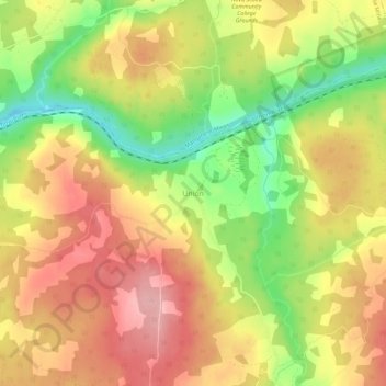
Naam: Topografische kaart Union, hoogte, reliëf.
Gemiddelde hoogte: 124 m
Minimale hoogte: 42 m
Maximale hoogte: 188 m
Andere topografische kaarten
Klik op een kaart om zijn topografie, zijn hoogte en zijn reliëf te bekijken.
MacKay Siding
Canada > Nova Scotia > Municipality of Colchester
MacKay Siding, Municipality of Colchester, Colchester County, Nova Scotia, Canada
Gemiddelde hoogte: 29 m
East Earltown
Canada > Nova Scotia > Municipality of Colchester
East Earltown, Municipality of Colchester, Colchester County, Nova Scotia, Canada
Gemiddelde hoogte: 111 m
Brentwood
Canada > Nova Scotia > Municipality of Colchester
Brentwood, Municipality of Colchester, Colchester County, Nova Scotia, Canada
Gemiddelde hoogte: 47 m
Fort Ellis
Canada > Nova Scotia > Municipality of Colchester
Fort Ellis, Municipality of Colchester, Colchester County, Nova Scotia, Canada
Gemiddelde hoogte: 28 m
Staples Brook
Canada > Nova Scotia > Municipality of Colchester
Staples Brook, Belmont, Municipality of Colchester, Colchester County, Nova Scotia, Canada
Gemiddelde hoogte: 69 m
Central North River
Canada > Nova Scotia > Municipality of Colchester
Central North River, Municipality of Colchester, Colchester County, Nova Scotia, Canada
Gemiddelde hoogte: 111 m
Pembroke
Canada > Nova Scotia > Municipality of Colchester
Pembroke, Municipality of Colchester, Colchester County, Nova Scotia, Canada
Gemiddelde hoogte: 110 m
Keeble
Canada > Nova Scotia > Municipality of Colchester > Keble
Keeble, Keble, Municipality of Colchester, Colchester County, Nova Scotia, Canada
Gemiddelde hoogte: 33 m
Brookfield
Canada > Nova Scotia > Municipality of Colchester
Brookfield, Municipality of Colchester, Colchester County, Nova Scotia, B0N 1C0, Canada
Gemiddelde hoogte: 98 m
Lanesville
Canada > Nova Scotia > Municipality of Colchester
Lanesville, Municipality of Colchester, Colchester County, Nova Scotia, Canada
Gemiddelde hoogte: 52 m
Onslow Mountain
Canada > Nova Scotia > Municipality of Colchester > Onslow Mountain
Onslow Mountain, Municipality of Colchester, Colchester County, Nova Scotia, Canada
Gemiddelde hoogte: 115 m
West New Annan
Canada > Nova Scotia > Municipality of Colchester
West New Annan, Municipality of Colchester, Colchester County, Nova Scotia, Canada
Gemiddelde hoogte: 138 m
Clifton
Canada > Nova Scotia > Municipality of Colchester > Clifton
Clifton, Municipality of Colchester, Colchester County, Nova Scotia, Canada
Gemiddelde hoogte: 31 m
Shubenacadie East
Canada > Nova Scotia > Municipality of Colchester > Shubenacadie East
Shubenacadie East, Municipality of Colchester, Colchester County, Nova Scotia, Canada
Gemiddelde hoogte: 28 m
Beaver Brook
Canada > Nova Scotia > Municipality of Colchester
Beaver Brook, Municipality of Colchester, Colchester County, Nova Scotia, Canada
Gemiddelde hoogte: 71 m
Earltown
Canada > Nova Scotia > Municipality of Colchester
Earltown, Municipality of Colchester, Colchester County, Nova Scotia, Canada
Gemiddelde hoogte: 202 m
Valley Station
Canada > Nova Scotia > Municipality of Colchester > Valley Station
Valley Station, Valley, Municipality of Colchester, Colchester County, Nova Scotia, B6L 2Y2, Canada
Gemiddelde hoogte: 60 m
Bass River
Canada > Nova Scotia > Municipality of Colchester
Bass River, Municipality of Colchester, Colchester County, Nova Scotia, B0M 1E0, Canada
Gemiddelde hoogte: 145 m
Upper Brookfield
Canada > Nova Scotia > Municipality of Colchester > Upper Brookfield
Upper Brookfield, Brookfield, Municipality of Colchester, Colchester County, Nova Scotia, B0N 1C0, Canada
Gemiddelde hoogte: 62 m
Economy
Canada > Nova Scotia > Municipality of Colchester
Economy, Municipality of Colchester, Colchester County, Nova Scotia, B0M 1J0, Canada
Gemiddelde hoogte: 93 m