
Topografische kaart Leverett
Interactieve kaart
Klik op de kaart om de hoogte weer te geven.
Over deze kaart
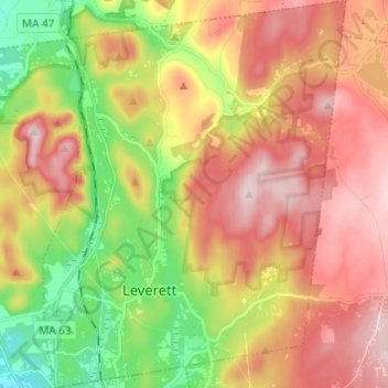
Naam: Topografische kaart Leverett, hoogte, reliëf.
Gemiddelde hoogte: 220 m
Minimale hoogte: 45 m
Maximale hoogte: 384 m
According to the United States Census Bureau, the town has a total area of 23.0 square miles (60 km2), of which 22.9 square miles (59 km2) are land and 0.1-square-mile (0.26 km2) (0.61%) is water. Leverett is located on the edge of the Pioneer Valley and the hills of northwestern Massachusetts, just east of the Connecticut River. The southwestern corner of town is relatively flat plains, while the rest is dominated by hills, the tallest of which is Brushy Mountain, with an elevation of 1,260 feet (380 m).
Andere topografische kaarten
Klik op een kaart om zijn topografie, zijn hoogte en zijn reliëf te bekijken.
Greenfield
United States > Massachusetts > Franklin County
Greenfield, Franklin County, Massachusetts, 01301, United States
Gemiddelde hoogte: 117 m
Leyden
United States > Massachusetts > Franklin County
Leyden, Franklin County, Massachusetts, United States
Gemiddelde hoogte: 249 m
Conway
United States > Massachusetts > Franklin County
Conway, Franklin County, Massachusetts, 01341, United States
Gemiddelde hoogte: 238 m
Swift River
United States > Massachusetts > Franklin County > Ashfield
Swift River, Ashfield, Franklin County, Massachusetts, 01070, United States
Gemiddelde hoogte: 435 m
Doolittle Brook Conservation Area
United States > Massachusetts > Franklin County > Leverett
Doolittle Brook Conservation Area, Rattlesnake Gutter Road, Leverett, Franklin County, Massachusetts, 01054, United States
Gemiddelde hoogte: 192 m