
Topografische kaart Sugar Hill
Interactieve kaart
Klik op de kaart om de hoogte weer te geven.
Over deze kaart
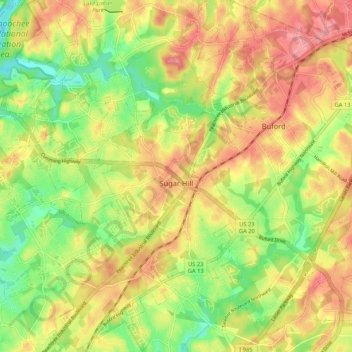
Naam: Topografische kaart Sugar Hill, hoogte, reliëf.
Locatie: Sugar Hill, Gwinnett County, Georgia, United States (34.06466 -84.10169 34.15187 -84.01418)
Gemiddelde hoogte: 332 m
Minimale hoogte: 277 m
Maximale hoogte: 383 m
According to the United States Census Bureau, as of 2010 the city of Sugar Hill had a total land area of 10.6 square miles (27.5 km2), of which 0.04 square miles (0.1 km2), or 0.33%, was water. The U.S. Geological Survey lists the city's elevation as 1,149 feet (350 m).
Andere topografische kaarten
Klik op een kaart om zijn topografie, zijn hoogte en zijn reliëf te bekijken.
Suwanee
United States > Georgia > Gwinnett County
Suwanee, Gwinnett County, Georgia, United States
Gemiddelde hoogte: 311 m
Rest Haven
United States > Georgia > Gwinnett County
Rest Haven, Gwinnett County, Georgia, United States
Gemiddelde hoogte: 349 m
Berkeley Lake
United States > Georgia > Gwinnett County
Berkeley Lake, Gwinnett County, Georgia, United States
Gemiddelde hoogte: 311 m
Mountain Park
United States > Georgia > Gwinnett County
Mountain Park, Gwinnett County, Georgia, 30047, United States
Gemiddelde hoogte: 292 m
Lawrenceville
United States > Georgia > Gwinnett County
Lawrenceville, Gwinnett County, Georgia, United States
Gemiddelde hoogte: 312 m
Myrdell Estates
United States > Georgia > Gwinnett County
Myrdell Estates, Gwinnett County, Georgia, 30519, United States
Gemiddelde hoogte: 355 m
Oak Village
United States > Georgia > Gwinnett County
Oak Village, Gwinnett County, Georgia, 30043, United States
Gemiddelde hoogte: 316 m
Duluth
United States > Georgia > Gwinnett County
Duluth, Gwinnett County, Georgia, United States
Gemiddelde hoogte: 305 m
Lilburn
United States > Georgia > Gwinnett County
Lilburn, Gwinnett County, Georgia, United States
Gemiddelde hoogte: 291 m
Peachtree Corners
United States > Georgia > Gwinnett County
Peachtree Corners, Gwinnett County, Georgia, 30092, United States
Gemiddelde hoogte: 303 m
Grayson
United States > Georgia > Gwinnett County
Grayson, Gwinnett County, Georgia, United States
Gemiddelde hoogte: 319 m
Berry Lake
United States > Georgia > Gwinnett County > Suwanee
Berry Lake, Suwanee, Gwinnett County, Georgia, United States
Gemiddelde hoogte: 304 m
Harbins Park
United States > Georgia > Gwinnett County
Harbins Park, Gwinnett County, Georgia, 30045-6560, United States
Gemiddelde hoogte: 271 m
Settles Bridge
United States > Georgia > Gwinnett County > Suwanee > Settles Bridge
Settles Bridge, Suwanee, Gwinnett County, Georgia, 30024, United States
Gemiddelde hoogte: 314 m
Duluth
United States > Georgia > Gwinnett County > Duluth
Duluth, Gwinnett County, Georgia, 30096, United States
Gemiddelde hoogte: 304 m
Dacula
United States > Georgia > Gwinnett County
Dacula, Gwinnett County, Georgia, United States
Gemiddelde hoogte: 313 m
Buford
United States > Georgia > Gwinnett County
Buford, Gwinnett County, Georgia, United States
Gemiddelde hoogte: 340 m
Rock Creek Estates
United States > Georgia > Gwinnett County > Buford > Rock Creek Estates
Rock Creek Estates, Buford, Gwinnett County, Georgia, 30519, United States
Gemiddelde hoogte: 338 m
Snellville
United States > Georgia > Gwinnett County
Snellville, Gwinnett County, Georgia, United States
Gemiddelde hoogte: 300 m
Norcross
United States > Georgia > Gwinnett County
Norcross, Gwinnett County, Georgia, 30071, United States
Gemiddelde hoogte: 309 m