
Doe een donatie
Rust jezelf uit voor je volgende avontuur:
Als Amazon-partner verdient deze site een commissie op in aanmerking komende aankopen, zonder extra kosten voor jou.
Topografische kaart Poros
Klik op de kaart om de hoogte weer te geven.
Doe een donatie
Rust jezelf uit voor je volgende avontuur:
Als Amazon-partner verdient deze site een commissie op in aanmerking komende aankopen, zonder extra kosten voor jou.
Poros
The land area of the municipality is 49.582 square kilometres (19.144 sq mi). This includes the islands and part of the adjacent Peloponnese coast, adjacent to Galatas, Thermisia and the island of Hydra. The landscape is very hilly and mountainous. The highest peak is the Vigla (358 m) in the west-central part. Following the island's topography and geology, small creeks and seasonal streams flow through steep valleys of the southern and northeastern part. The western and northern part of the island feature smooth hills and shallow valleys. Sandy beaches are restricted to the southern shore of the island, except for a bay in the northern part called Vayionia.
Doe een donatie
Rust jezelf uit voor je volgende avontuur:
Als Amazon-partner verdient deze site een commissie op in aanmerking komende aankopen, zonder extra kosten voor jou.
Over deze kaart
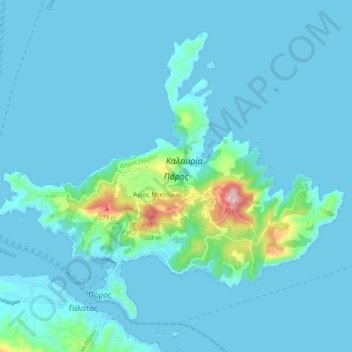
Naam: Topografische kaart Poros, hoogte, reliëf.
Gemiddelde hoogte: 31 m
Minimale hoogte: -1 m
Maximale hoogte: 351 m
Doe een donatie
Rust jezelf uit voor je volgende avontuur:
Als Amazon-partner verdient deze site een commissie op in aanmerking komende aankopen, zonder extra kosten voor jou.