
Doe een donatie
Rust jezelf uit voor je volgende avontuur:
Als Amazon-partner verdient deze site een commissie op in aanmerking komende aankopen, zonder extra kosten voor jou.
Topografische kaart Borstel-Hohenraden
Klik op de kaart om de hoogte weer te geven.
Doe een donatie
Rust jezelf uit voor je volgende avontuur:
Als Amazon-partner verdient deze site een commissie op in aanmerking komende aankopen, zonder extra kosten voor jou.
Borstel-Hohenraden
On the origin and meaning of the name: "Tho the Borstelde" in "Kerspell Rellinghen" clearly indicate our Borstel. Over the centuries, the name of Borstelde over Borstele, Borstell, Borsteler altered, Barstell to Borstel (the Urdorf). Originally, the name comes from the Old Saxon "bur" = home and "Stal" = location facility. The name can be found very often, not only in Schleswig-Holstein, but also in Hamburg and Lower Saxony. The name of the daughter of the village Hohenraden indicates a later scale of Borstelern cleared area. Yet 1688 is this place called "the Hohenrade" and only in the 19th century. Is the place name Hohenraden. Rade (Rode) means clearing, so the high-altitude clearance. It was also suggested that it was the settlement that was only with the "high wheel" available. Structurally, the municipality Borstel-Hohenraden has developed in recent years from a farming village into a residential community. The aim is to preserve the functions of housing and agriculture alike. The community is faced with the task of infrastructural measures to improve the quality of living for the people living in the municipality inhabitants constantly.
Doe een donatie
Rust jezelf uit voor je volgende avontuur:
Als Amazon-partner verdient deze site een commissie op in aanmerking komende aankopen, zonder extra kosten voor jou.
Over deze kaart
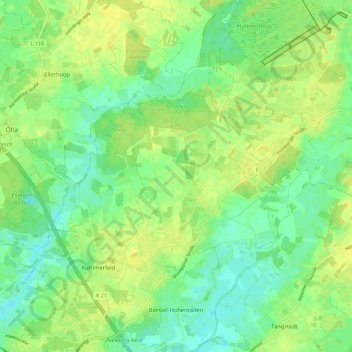
Naam: Topografische kaart Borstel-Hohenraden, hoogte, reliëf.
Gemiddelde hoogte: 12 m
Minimale hoogte: 1 m
Maximale hoogte: 22 m
Doe een donatie
Rust jezelf uit voor je volgende avontuur:
Als Amazon-partner verdient deze site een commissie op in aanmerking komende aankopen, zonder extra kosten voor jou.
Andere topografische kaarten
Klik op een kaart om zijn topografie, zijn hoogte en zijn reliëf te bekijken.