
Topografische kaart La Hieullerie
Interactieve kaart
Klik op de kaart om de hoogte weer te geven.
Over deze kaart
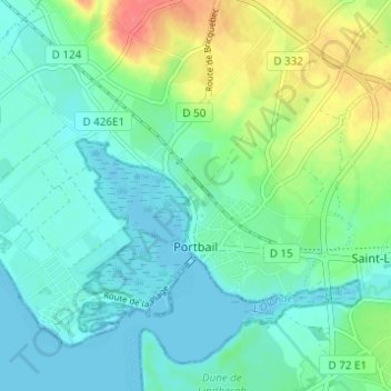
Naam: Topografische kaart La Hieullerie, hoogte, reliëf.
Gemiddelde hoogte: 16 m
Minimale hoogte: -1 m
Maximale hoogte: 56 m
Andere topografische kaarten
Klik op een kaart om zijn topografie, zijn hoogte en zijn reliëf te bekijken.
Village du Havre
France > Normandie > Manche > Port-Bail-sur-Mer > Portbail
Village du Havre, Portbail, Port-Bail-sur-Mer, Cherbourg, Manche, Normandie, France métropolitaine, 50580, France
Gemiddelde hoogte: 15 m
Saint-Marc
France > Normandie > Manche > Port-Bail-sur-Mer > Portbail
Saint-Marc, Portbail, Port-Bail-sur-Mer, Cherbourg, Manche, Normandie, France métropolitaine, 50580, France
Gemiddelde hoogte: 20 m
Les Acacias
France > Normandie > Manche > Port-Bail-sur-Mer > Portbail
Les Acacias, Portbail, Port-Bail-sur-Mer, Cherbourg, Manche, Normandie, France métropolitaine, 50580, France
Gemiddelde hoogte: 6 m
Les Forges
France > Normandie > Manche > Port-Bail-sur-Mer > Portbail
Les Forges, Portbail, Port-Bail-sur-Mer, Cherbourg, Manche, Normandie, France métropolitaine, 50580, France
Gemiddelde hoogte: 18 m