
Topografische kaart Ausserberg
Interactieve kaart
Klik op de kaart om de hoogte weer te geven.
Ausserberg
The municipality is located in the Westlich Raron district, on the northern slope of the Rhone valley between the Baltschiederbach and the Bietschhorn mountain. It consists of a number of scattered settlements with the central village of Trogdorf at an elevation of 1,008 m (3,307 ft).
Over deze kaart
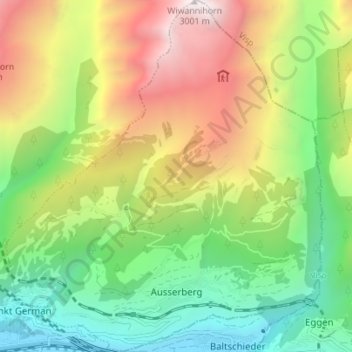
Naam: Topografische kaart Ausserberg, hoogte, reliëf.
Locatie: Ausserberg, Westlich Raron, Valais/Wallis, Switzerland (46.30718 7.81901 46.35498 7.88132)
Gemiddelde hoogte: 1.580 m
Minimale hoogte: 638 m
Maximale hoogte: 2.997 m