
Topografische kaart Canterbury
Interactieve kaart
Klik op de kaart om de hoogte weer te geven.
Over deze kaart
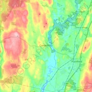
Naam: Topografische kaart Canterbury, hoogte, reliëf.
Gemiddelde hoogte: 90 m
Minimale hoogte: 28 m
Maximale hoogte: 182 m
Andere topografische kaarten
Klik op een kaart om zijn topografie, zijn hoogte en zijn reliëf te bekijken.
Eastford
United States > Connecticut > Windham County
Eastford, Windham County, Connecticut, 06242, United States
Gemiddelde hoogte: 200 m
Brooklyn
United States > Connecticut > Windham County
Brooklyn, Windham County, Connecticut, 06234, United States
Gemiddelde hoogte: 102 m
Putnam
United States > Connecticut > Windham County
Putnam, Windham County, Connecticut, 06260, United States
Gemiddelde hoogte: 123 m
Ashford
United States > Connecticut > Windham County > Ashford
Ashford, Windham County, Connecticut, United States
Gemiddelde hoogte: 202 m
Dayville
United States > Connecticut > Windham County > Killingly > Dayville
Dayville, Killingly, Windham County, Connecticut, United States
Gemiddelde hoogte: 91 m