
Topografische kaart Britton Hill
Interactieve kaart
Klik op de kaart om de hoogte weer te geven.
Over deze kaart
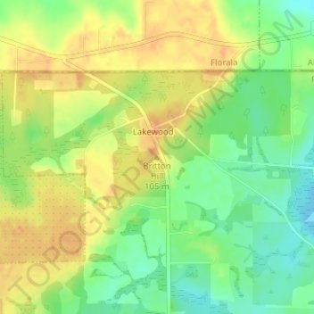
Naam: Topografische kaart Britton Hill, hoogte, reliëf.
Locatie: Britton Hill, Walton County, Florida, 32538, United States (30.98636 -86.28157 30.98646 -86.28147)
Gemiddelde hoogte: 93 m
Minimale hoogte: 73 m
Maximale hoogte: 109 m
Britton Hill is the highest natural point in the state of Florida, United States, with a summit elevation of 345 feet (105 meters) above mean sea level. Britton Hill is the lowest state highpoint in the United States, 103 feet (31 m) lower than the next lowest highpoint, Ebright Azimuth in Delaware, and far lower than many skyscrapers in Miami and other urban areas of Florida.
Andere topografische kaarten
Klik op een kaart om zijn topografie, zijn hoogte en zijn reliëf te bekijken.
Blue Mountain
United States > Florida > Walton County > Santa Rosa Beach
Blue Mountain, Santa Rosa Beach, Walton County, Florida, 32459, United States
Gemiddelde hoogte: 9 m
Miramar Beach
United States > Florida > Walton County
Miramar Beach, Walton County, Florida, United States
Gemiddelde hoogte: 2 m
Freeport
United States > Florida > Walton County
Freeport, Walton County, Florida, 32439, United States
Gemiddelde hoogte: 14 m
Redbay
United States > Florida > Walton County
Redbay, Walton County, Florida, 32455, United States
Gemiddelde hoogte: 32 m
Seaside
United States > Florida > Walton County
Seaside, Walton County, Florida, United States
Gemiddelde hoogte: 5 m
DeFuniak Springs
United States > Florida > Walton County
DeFuniak Springs, Walton County, Florida, 32435, United States
Gemiddelde hoogte: 56 m
Santa Rosa Beach
United States > Florida > Walton County
Santa Rosa Beach, Walton County, Florida, 32459, United States
Gemiddelde hoogte: 4 m