
Topografische kaart Little Switzerland
Interactieve kaart
Klik op de kaart om de hoogte weer te geven.
Over deze kaart
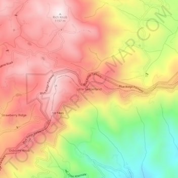
Naam: Topografische kaart Little Switzerland, hoogte, reliëf.
Gemiddelde hoogte: 935 m
Minimale hoogte: 554 m
Maximale hoogte: 1.196 m
Little Switzerland is an unincorporated community in McDowell and Mitchell counties of North Carolina, United States. It is located along North Carolina Highway 226A (NC 226A) off the Blue Ridge Parkway, directly north of Marion and south of Spruce Pine. The elevation is 3,468 feet (1,057 m) above sea level.
Andere topografische kaarten
Klik op een kaart om zijn topografie, zijn hoogte en zijn reliëf te bekijken.
West Marion
United States > North Carolina > McDowell County
West Marion, McDowell County, North Carolina, 28752, United States
Gemiddelde hoogte: 449 m
Marion
United States > North Carolina > McDowell County
Marion, McDowell County, North Carolina, 28752, United States
Gemiddelde hoogte: 435 m
Nebo
United States > North Carolina > McDowell County
Nebo, McDowell County, North Carolina, 28761, United States
Gemiddelde hoogte: 394 m
Old Fort
United States > North Carolina > McDowell County
Old Fort, McDowell County, North Carolina, United States
Gemiddelde hoogte: 474 m