
Topografische kaart Visakhapatnam
Interactieve kaart
Klik op de kaart om de hoogte weer te geven.
Over deze kaart
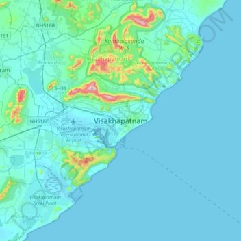
Naam: Topografische kaart Visakhapatnam, hoogte, reliëf.
Gemiddelde hoogte: 41 m
Minimale hoogte: -2 m
Maximale hoogte: 519 m
The city is situated between the Eastern Ghats and the Bay of Bengal. The city coordinates lies between 17.7041 N and 83.2977 E. The city's area is 682 km2. The average elevation is 45 metres. Visakhpatnam is situated in Coastal Andhra Region.