
Topografische kaart Cloudland Canyon State Park
Interactieve kaart
Klik op de kaart om de hoogte weer te geven.
Cloudland Canyon State Park
Cloudland Canyon State Park is a 3,485 acres (14.10 km2) Georgia state park located near Trenton and Cooper Heights on the western edge of Lookout Mountain. One of the largest and most scenic parks in Georgia, it contains rugged geology, and offers visitors a range of vistas across the deep gorge cut through the mountain by Sitton Gulch Creek, where the elevation varies from 800 to over 1,800 feet. Views of the canyon can be seen from the picnic area parking lot, in addition to additional views located along the rim trail. At the bottom of the gorge, two waterfalls cascade across layers of sandstone and shale, ending in small pools below.
Over deze kaart
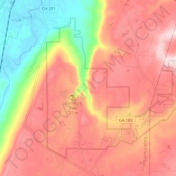
Naam: Topografische kaart Cloudland Canyon State Park, hoogte, reliëf.
Gemiddelde hoogte: 488 m
Minimale hoogte: 210 m
Maximale hoogte: 681 m
Andere topografische kaarten
Klik op een kaart om zijn topografie, zijn hoogte en zijn reliëf te bekijken.