
Topografische kaart Iron Mountain
Interactieve kaart
Klik op de kaart om de hoogte weer te geven.
Over deze kaart
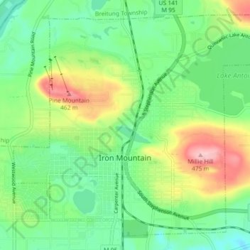
Naam: Topografische kaart Iron Mountain, hoogte, reliëf.
Locatie: Iron Mountain, Dickinson County, Michigan, United States (45.80456 -88.09815 45.84894 -88.02630)
Gemiddelde hoogte: 365 m
Minimale hoogte: 304 m
Maximale hoogte: 482 m
Iron Mountain is included in the Marquette television market, NBC affiliate WLUC operates a local news bureau covering the city and neighboring areas. Due to distance from the transmitters and topography in the region terrestrial television signals are very limited in the area with the strongest signal coming from Wisconsin Public Television translator station W30DZ originating from Fence, WI.
Andere topografische kaarten
Klik op een kaart om zijn topografie, zijn hoogte en zijn reliëf te bekijken.
Metropolitan
United States > Michigan > Dickinson County
Metropolitan, Felch Township, Dickinson County, Michigan, 49831, United States
Gemiddelde hoogte: 371 m
Norway Township
United States > Michigan > Dickinson County
Norway Township, Dickinson County, Michigan, United States
Gemiddelde hoogte: 325 m
Kingsford
United States > Michigan > Dickinson County > Kingsford
Kingsford, Dickinson County, Michigan, 49802, United States
Gemiddelde hoogte: 350 m
Norway
United States > Michigan > Dickinson County
Norway, Dickinson County, Michigan, 49870, United States
Gemiddelde hoogte: 311 m