
Topografische kaart Arbaz
Interactieve kaart
Klik op de kaart om de hoogte weer te geven.
Over deze kaart
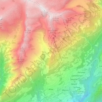
Naam: Topografische kaart Arbaz, hoogte, reliëf.
Locatie: Arbaz, Sion, Wallis, 1974, Switzerland (46.26372 7.35024 46.34049 7.39863)
Gemiddelde hoogte: 1.720 m
Minimale hoogte: 535 m
Maximale hoogte: 2.883 m
The municipality is located in the Sion district, at an elevation of between 830 and 2,886 m (2,723 and 9,469 ft). Until 1877 it was part of the municipality of Ayent. The village of Arbaz was partially destroyed by fire in 1924, but has been rebuilt. Almost half of the houses in the village are vacation homes. It is situated on the north bank of the Rhône River.
Andere topografische kaarten
Klik op een kaart om zijn topografie, zijn hoogte en zijn reliëf te bekijken.
Sex Noir
Switzerland > Wallis > Sion > Arbaz
Sex Noir, Arbaz, Sion, Wallis, 1974, Switzerland
Gemiddelde hoogte: 2.290 m
Veysonnaz
Switzerland > Wallis > Sion
Veysonnaz, Sion, Wallis, 1993, Switzerland
Gemiddelde hoogte: 1.020 m
Les Mountons
Switzerland > Wallis > Sion > Savièse
Les Mountons, Savièse, Sion, Wallis, 1965, Switzerland
Gemiddelde hoogte: 2.228 m