
Topografische kaart Mill Run
Interactieve kaart
Klik op de kaart om de hoogte weer te geven.
Over deze kaart
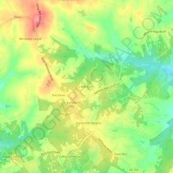
Naam: Topografische kaart Mill Run, hoogte, reliëf.
Locatie: Mill Run, Albemarle County, Virginia, 22936, United States (38.14130 -78.49900 38.18130 -78.45900)
Gemiddelde hoogte: 177 m
Minimale hoogte: 134 m
Maximale hoogte: 222 m
Andere topografische kaarten
Klik op een kaart om zijn topografie, zijn hoogte en zijn reliëf te bekijken.
Franklin
United States > Virginia > Albemarle County
Franklin, Albemarle County, Virginia, 22909, United States
Gemiddelde hoogte: 150 m
Solaris
United States > Virginia > Albemarle County
Solaris, Albemarle County, Virginia, 22923, United States
Gemiddelde hoogte: 145 m
Pantops
United States > Virginia > Albemarle County
Pantops, Albemarle County, Virginia, 22909, United States
Gemiddelde hoogte: 147 m
Four Seasons
United States > Virginia > Albemarle County
Four Seasons, Albemarle County, Virginia, 22901, United States
Gemiddelde hoogte: 151 m
Ivy
United States > Virginia > Albemarle County
Ivy, Albemarle County, Virginia, 22945, United States
Gemiddelde hoogte: 189 m
Northfields
United States > Virginia > Albemarle County
Northfields, Albemarle County, Virginia, 22911, United States
Gemiddelde hoogte: 134 m
Crozet
United States > Virginia > Albemarle County > Crozet
Crozet, Albemarle County, Virginia, 23932, United States
Gemiddelde hoogte: 234 m
Blueridge Forest
United States > Virginia > Albemarle County
Blueridge Forest, Albemarle County, Virginia, 22936, United States
Gemiddelde hoogte: 161 m
Mill Mountain
United States > Virginia > Albemarle County
Mill Mountain, Albemarle County, Virginia, 22931, United States
Gemiddelde hoogte: 363 m
High Top
United States > Virginia > Albemarle County
High Top, Albemarle County, Virginia, 22924, United States
Gemiddelde hoogte: 360 m
Chestnut Grove
United States > Virginia > Albemarle County > Chestnut Grove
Chestnut Grove, Albemarle County, Virginia, 22936, United States
Gemiddelde hoogte: 177 m
Damon
United States > Virginia > Albemarle County
Damon, Albemarle County, Virginia, 22969, United States
Gemiddelde hoogte: 171 m
Queen Charlotte
United States > Virginia > Albemarle County
Queen Charlotte, Albemarle County, Virginia, 22901, United States
Gemiddelde hoogte: 163 m