
Doe een donatie
Rust jezelf uit voor je volgende avontuur:
Als Amazon-partner verdient deze site een commissie op in aanmerking komende aankopen, zonder extra kosten voor jou.
Topografische kaart State College
Klik op de kaart om de hoogte weer te geven.
Doe een donatie
Rust jezelf uit voor je volgende avontuur:
Als Amazon-partner verdient deze site een commissie op in aanmerking komende aankopen, zonder extra kosten voor jou.
State College
Weather in State College is strongly influenced by the mountain and valley topology of the area. The surrounding mountains cause significantly lower temperatures in the winter, and make summer heat waves much rarer than in the rest of the state. Precipitation is about 20% lower than areas at comparable elevations, again due to the surrounding mountains. Snowfall typically occurs between October and April, but has happened as late as June.
Doe een donatie
Rust jezelf uit voor je volgende avontuur:
Als Amazon-partner verdient deze site een commissie op in aanmerking komende aankopen, zonder extra kosten voor jou.
Over deze kaart
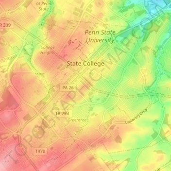
Naam: Topografische kaart State College, hoogte, reliëf.
Locatie: State College, Centre County, Pennsylvania, United States (40.76837 -77.88617 40.80723 -77.81900)
Gemiddelde hoogte: 351 m
Minimale hoogte: 286 m
Maximale hoogte: 398 m
Doe een donatie
Rust jezelf uit voor je volgende avontuur:
Als Amazon-partner verdient deze site een commissie op in aanmerking komende aankopen, zonder extra kosten voor jou.
Andere topografische kaarten
Klik op een kaart om zijn topografie, zijn hoogte en zijn reliëf te bekijken.
Dalevue Park
United States > Pennsylvania > Centre County > State College > Dalevue
Gemiddelde hoogte: 331 m
Doe een donatie
Rust jezelf uit voor je volgende avontuur:
Als Amazon-partner verdient deze site een commissie op in aanmerking komende aankopen, zonder extra kosten voor jou.
Loch Lomond Junction
United States > Pennsylvania > Centre County > Rush Township
Gemiddelde hoogte: 460 m