
Topografische kaart Walnut Grove
Interactieve kaart
Klik op de kaart om de hoogte weer te geven.
Over deze kaart
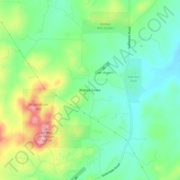
Naam: Topografische kaart Walnut Grove, hoogte, reliëf.
Locatie: Walnut Grove, Kendall County, Texas, United States (29.84827 -98.75475 29.88827 -98.71475)
Gemiddelde hoogte: 455 m
Minimale hoogte: 396 m
Maximale hoogte: 568 m
Andere topografische kaarten
Klik op een kaart om zijn topografie, zijn hoogte en zijn reliëf te bekijken.
Boerne
United States > Texas > Kendall County
Boerne, Kendall County, Texas, United States
Gemiddelde hoogte: 465 m
Kreutzberg
United States > Texas > Kendall County
Kreutzberg, Kendall County, Texas, United States
Gemiddelde hoogte: 426 m
Boerne
United States > Texas > Kendall County
Boerne, Kendall County, Texas, United States
Gemiddelde hoogte: 465 m
Bergheim
United States > Texas > Kendall County
Bergheim, Kendall County, Texas, 78004, United States
Gemiddelde hoogte: 419 m
Waring
United States > Texas > Kendall County
Waring, Kendall County, Texas, 78074, United States
Gemiddelde hoogte: 425 m
Comfort
United States > Texas > Kendall County
Comfort, Kendall County, Texas, 70813, United States
Gemiddelde hoogte: 457 m
Nelson City
United States > Texas > Kendall County
Nelson City, Kendall County, Texas, United States
Gemiddelde hoogte: 485 m