
Topografische kaart Fuquay-Varina
Interactieve kaart
Klik op de kaart om de hoogte weer te geven.
Over deze kaart
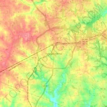
Naam: Topografische kaart Fuquay-Varina, hoogte, reliëf.
Gemiddelde hoogte: 120 m
Minimale hoogte: 75 m
Maximale hoogte: 150 m
Fuquay-Varina is located in the northeast central region of North Carolina, where the North American Piedmont and Atlantic Coastal Plain regions meet. This area is known as the "Fall Line" because it marks the elevation inland at which waterfalls begin to appear in creeks and rivers. Its central Piedmont location situates Fuquay-Varina about three hours west of Atlantic Beach, North Carolina, by car and four hours east of the Great Smoky Mountains.