
Topografische kaart Cape Coral
Interactieve kaart
Klik op de kaart om de hoogte weer te geven.
Over deze kaart
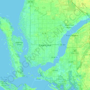
Naam: Topografische kaart Cape Coral, hoogte, reliëf.
Locatie: Cape Coral, Lee County, Florida, 33914-4648, United States (26.44594 -82.14068 26.76594 -81.82068)
Gemiddelde hoogte: 3 m
Minimale hoogte: -2 m
Maximale hoogte: 13 m
Andere topografische kaarten
Klik op een kaart om zijn topografie, zijn hoogte en zijn reliëf te bekijken.
Calusa Land Trust and Nature Preserve of Pine Island
United States > Florida > Lee County > Cape Coral
Calusa Land Trust and Nature Preserve of Pine Island, Cape Coral, Lee County, Florida, United States
Gemiddelde hoogte: 1 m
Coral Lakes
United States > Florida > Lee County > Cape Coral
Coral Lakes, Cape Coral, Lee County, Florida, 33909, United States
Gemiddelde hoogte: 6 m
McDonough Canal
United States > Florida > Lee County > Cape Coral
McDonough Canal, Cape Coral, Lee County, Florida, 33991, United States
Gemiddelde hoogte: 3 m
Sacremento Canal
United States > Florida > Lee County > Cape Coral
Sacremento Canal, Cape Coral, Lee County, Florida, 33904, United States
Gemiddelde hoogte: 4 m