
Topografische kaart Isérables
Interactieve kaart
Klik op de kaart om de hoogte weer te geven.
Over deze kaart
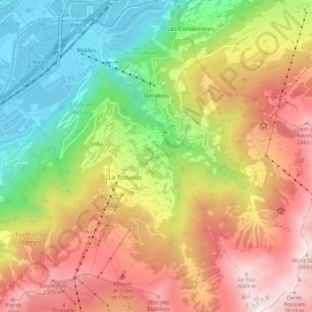
Naam: Topografische kaart Isérables, hoogte, reliëf.
Locatie: Isérables, Martigny, Wallis, 1914, Switzerland (46.11528 7.23014 46.18258 7.29556)
Gemiddelde hoogte: 1.504 m
Minimale hoogte: 464 m
Maximale hoogte: 2.709 m
Andere topografische kaarten
Klik op een kaart om zijn topografie, zijn hoogte en zijn reliëf te bekijken.
Saillon
Switzerland > Wallis > Martigny
Saillon, Martigny, Wallis, 1913, Switzerland
Gemiddelde hoogte: 975 m
Saxon
Switzerland > Wallis > Martigny
Saxon, Martigny, Wallis, 1907, Switzerland
Gemiddelde hoogte: 1.062 m
Col de la Forclaz
Switzerland > Wallis > Martigny > Trient > Col de la Forclaz
Col de la Forclaz, Trient, Martigny, Wallis, 1929, Switzerland
Gemiddelde hoogte: 1.637 m
La Tzoumaz
Switzerland > Wallis > Martigny
La Tzoumaz, Riddes, Martigny, Wallis, 1918, Switzerland
Gemiddelde hoogte: 1.467 m
Riddes
Switzerland > Wallis > Martigny
Riddes, Martigny, Wallis, Switzerland
Gemiddelde hoogte: 1.410 m
Fully
Switzerland > Wallis > Martigny
Fully, Martigny, Wallis, 1926, Switzerland
Gemiddelde hoogte: 1.390 m