
Topografische kaart Saint-Amand-Villages
Interactieve kaart
Klik op de kaart om de hoogte weer te geven.
Over deze kaart
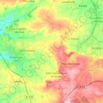
Naam: Topografische kaart Saint-Amand-Villages, hoogte, reliëf.
Gemiddelde hoogte: 137 m
Minimale hoogte: 45 m
Maximale hoogte: 236 m
Andere topografische kaarten
Klik op een kaart om zijn topografie, zijn hoogte en zijn reliëf te bekijken.
L'Angle
France > Normandie > Manche > Condé-sur-Vire
L'Angle, Condé-sur-Vire, Saint-Lô, Manche, Normandie, France métropolitaine, 50890, France
Gemiddelde hoogte: 78 m
Utah-Beach
France > Normandie > Manche > Sainte-Marie-du-Mont
Utah-Beach, Sainte-Marie-du-Mont, Cherbourg, Manche, Normandie, France métropolitaine, 50480, France
Gemiddelde hoogte: 1 m
Saint-Pierre-Langers
Saint-Pierre-Langers, Avranches, Manche, Normandie, France métropolitaine, 50530, France
Gemiddelde hoogte: 68 m
Le Mont-Saint-Michel
Le Mont-Saint-Michel, Avranches, Manche, Normandie, France métropolitaine, 50170, France
Gemiddelde hoogte: 5 m
Reffuveille
Reffuveille, Avranches, Manche, Normandie, France métropolitaine, 50520, France
Gemiddelde hoogte: 185 m
Tombelaine
France > Normandie > Manche > Genêts
Tombelaine, Genêts, Avranches, Manche, Normandie, France métropolitaine, 50530, France
Gemiddelde hoogte: 67 m
Guilberville
France > Normandie > Manche > Torigny-les-Villes
Guilberville, Torigny-les-Villes, Saint-Lô, Manche, Normandie, France métropolitaine, 50160, France
Gemiddelde hoogte: 165 m
Acqueville
France > Normandie > Manche > La Hague
Acqueville, La Hague, Cherbourg, Manche, Normandie, France métropolitaine, 50440, France
Gemiddelde hoogte: 119 m
Bellefeuille
France > Normandie > Manche > Martinvast
Bellefeuille, Martinvast, Cherbourg, Manche, Normandie, France métropolitaine, 50690, France
Gemiddelde hoogte: 85 m
Jullouville
France > Normandie > Manche > Jullouville
Jullouville, Avranches, Manche, Normandie, France métropolitaine, 50610, France
Gemiddelde hoogte: 29 m
La Douveterie
France > Normandie > Manche > La Lucerne-d'Outremer > La Douveterie
La Douveterie, La Lucerne-d'Outremer, Avranches, Manche, Normandie, France métropolitaine, 50320, France
Gemiddelde hoogte: 107 m
Les Hauts Vents
France > Normandie > Manche > Regnéville-sur-Mer > Les Hauts Vents
Les Hauts Vents, Regnéville-sur-Mer, Coutances, Manche, Normandie, France métropolitaine, 50590, France
Gemiddelde hoogte: 17 m
Zone humide
France > Normandie > Manche > Juilley > Le Gué au Râle
Zone humide, Le Gué au Râle, Juilley, Avranches, Manche, Normandie, France métropolitaine, 50220, France
Gemiddelde hoogte: 66 m
Condé-sur-Vire
France > Normandie > Manche > Condé-sur-Vire
Condé-sur-Vire, Saint-Lô, Manche, Normandie, France métropolitaine, 50890, France
Gemiddelde hoogte: 84 m
Cherbourg-en-Cotentin
Cherbourg-en-Cotentin, Cherbourg, Manche, Normandie, France métropolitaine, France
Gemiddelde hoogte: 67 m
Pierreville
Pierreville, Cherbourg, Manche, Normandie, France métropolitaine, 50340, France
Gemiddelde hoogte: 62 m