
Topografische kaart Woolwine
Interactieve kaart
Klik op de kaart om de hoogte weer te geven.
Over deze kaart
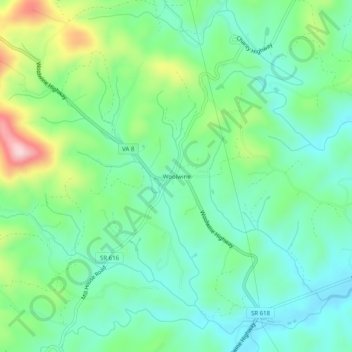
Naam: Topografische kaart Woolwine, hoogte, reliëf.
Locatie: Woolwine, Patrick County, Virginia, 24185, United States (36.76986 -80.29728 36.80986 -80.25728)
Gemiddelde hoogte: 454 m
Minimale hoogte: 376 m
Maximale hoogte: 647 m
Andere topografische kaarten
Klik op een kaart om zijn topografie, zijn hoogte en zijn reliëf te bekijken.
Poor Mountain
United States > Virginia > Patrick County
Poor Mountain, Patrick County, Virginia, United States
Gemiddelde hoogte: 373 m
Patrick Springs
United States > Virginia > Patrick County
Patrick Springs, Patrick County, Virginia, 24171, United States
Gemiddelde hoogte: 389 m
Critz
United States > Virginia > Patrick County
Critz, Patrick County, Virginia, 24082, United States
Gemiddelde hoogte: 336 m
Claudville
United States > Virginia > Patrick County
Claudville, Patrick County, Virginia, 24076, United States
Gemiddelde hoogte: 432 m
Groundhog Mountain
United States > Virginia > Patrick County
Groundhog Mountain, Patrick County, Virginia, 24053, United States
Gemiddelde hoogte: 814 m
Meadows of Dan
United States > Virginia > Patrick County
Meadows of Dan, Patrick County, Virginia, 24120, United States
Gemiddelde hoogte: 888 m
Stuart
United States > Virginia > Patrick County
Stuart, Patrick County, Virginia, United States
Gemiddelde hoogte: 411 m
Carters Mill
United States > Virginia > Patrick County > Carters Mill
Carters Mill, Patrick County, Virginia, United States
Gemiddelde hoogte: 456 m
Buffalo Ridge
United States > Virginia > Patrick County
Buffalo Ridge, Patrick County, Virginia, 24185, United States
Gemiddelde hoogte: 488 m