
Topografische kaart Col des Bagenelles
Interactieve kaart
Klik op de kaart om de hoogte weer te geven.
Over deze kaart
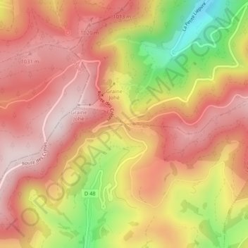
Naam: Topografische kaart Col des Bagenelles, hoogte, reliëf.
Gemiddelde hoogte: 897 m
Minimale hoogte: 580 m
Maximale hoogte: 1.082 m
Andere topografische kaarten
Klik op een kaart om zijn topografie, zijn hoogte en zijn reliëf te bekijken.
Col du Bonhomme
France > Grand Est > Le Bonhomme
Col du Bonhomme, D 415, Maison Forestière du Général Bataille, Le Bonhomme, Saint-Dié-des-Vosges, Haut-Rhin, Grand Est, France métropolitaine, 68650, France
Gemiddelde hoogte: 908 m
Col du Calvaire
France > Grand Est > Le Bonhomme
Col du Calvaire, Route des Crêtes, Maison Forestière du Général Bataille, Le Bonhomme, Saint-Dié-des-Vosges, Haut-Rhin, Grand Est, France métropolitaine, 68650, France
Gemiddelde hoogte: 1.073 m