
Topografische kaart Cashion Community
Interactieve kaart
Klik op de kaart om de hoogte weer te geven.
Over deze kaart
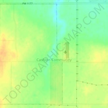
Naam: Topografische kaart Cashion Community, hoogte, reliëf.
Locatie: Cashion Community, Wichita County, Texas, United States (34.02446 -98.51904 34.04964 -98.49752)
Gemiddelde hoogte: 310 m
Minimale hoogte: 293 m
Maximale hoogte: 325 m
Cashion Community is located eight miles north of Wichita Falls off State Highway 240 in northeastern Wichita County. Its elevation is 994 feet above mean sea level. The city has a total area of 1.9 square miles (4.9 km2), all land.
Andere topografische kaarten
Klik op een kaart om zijn topografie, zijn hoogte en zijn reliëf te bekijken.
Wichita Falls
United States > Texas > Wichita County
Wichita Falls, Wichita County, Texas, United States
Gemiddelde hoogte: 300 m
Electra
United States > Texas > Wichita County
Electra, Wichita County, Texas, United States
Gemiddelde hoogte: 362 m
Pleasant Valley
United States > Texas > Wichita County
Pleasant Valley, Wichita County, Texas, United States
Gemiddelde hoogte: 298 m
Haynesville
United States > Texas > Wichita County
Haynesville, Wichita County, Texas, United States
Gemiddelde hoogte: 347 m
Burkburnett
United States > Texas > Wichita County
Burkburnett, Wichita County, Texas, 76354, United States
Gemiddelde hoogte: 315 m
Wichita Falls
United States > Texas > Wichita County
Wichita Falls, Wichita County, Texas, United States
Gemiddelde hoogte: 301 m
Bare Butte
United States > Texas > Wichita County
Bare Butte, Wichita County, Texas, United States
Gemiddelde hoogte: 304 m
Iowa Park
United States > Texas > Wichita County
Iowa Park, Wichita County, Texas, United States
Gemiddelde hoogte: 316 m