
Doe een donatie
Rust jezelf uit voor je volgende avontuur:
Als Amazon-partner verdient deze site een commissie op in aanmerking komende aankopen, zonder extra kosten voor jou.
Topografische kaart Iqaluit
Klik op de kaart om de hoogte weer te geven.
Doe een donatie
Rust jezelf uit voor je volgende avontuur:
Als Amazon-partner verdient deze site een commissie op in aanmerking komende aankopen, zonder extra kosten voor jou.
Iqaluit
Iqaluit has a tundra climate (Köppen: ET) typical of the Arctic region, although it is well outside the Arctic Circle. The city features long, cold winters and brief, cool summers. Average monthly temperatures are below freezing for eight months of the year. Iqaluit averages just over 400 mm (16 in) of precipitation annually, much wetter than many other localities in the Arctic Archipelago, with the summer being the wettest season. Temperatures of the winter months are comparable to other northern communities further west on the continent such as Yellowknife and to some extent even Fairbanks, Alaska, even though Iqaluit is a few degrees colder than the latter. Summer temperatures are, however, much colder due to its easterly maritime position affected by the waters of the cold Baffin Island Current. This means that the tree line is much further south in the eastern part of Canada, being as southbound, in spite of low elevation, as northern Labrador.
Doe een donatie
Rust jezelf uit voor je volgende avontuur:
Als Amazon-partner verdient deze site een commissie op in aanmerking komende aankopen, zonder extra kosten voor jou.
Over deze kaart
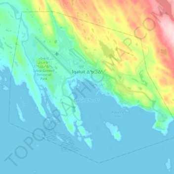
Naam: Topografische kaart Iqaluit, hoogte, reliëf.
Locatie: Iqaluit, ᐃᖃᓗᐃᑦ, Qikiqtaaluk Region, Nunavut, Canada (63.70852 -68.60121 63.77634 -68.42543)
Gemiddelde hoogte: 50 m
Minimale hoogte: 0 m
Maximale hoogte: 250 m
Doe een donatie
Rust jezelf uit voor je volgende avontuur:
Als Amazon-partner verdient deze site een commissie op in aanmerking komende aankopen, zonder extra kosten voor jou.
Andere topografische kaarten
Klik op een kaart om zijn topografie, zijn hoogte en zijn reliëf te bekijken.