
Topografische kaart Ploiești
Interactieve kaart
Klik op de kaart om de hoogte weer te geven.
Over deze kaart
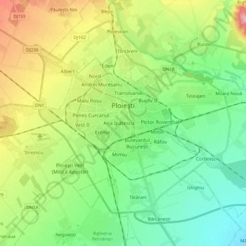
Naam: Topografische kaart Ploiești, hoogte, reliëf.
Locatie: Ploiești, Prahova, Romania (44.89614 25.91790 44.96842 26.10197)
Gemiddelde hoogte: 158 m
Minimale hoogte: 105 m
Maximale hoogte: 264 m
The city lies on the Wallachian Plain, having an average altitude of 150 m (490 ft). The surrounding landscape is influenced by its position around the Prahova River, whose stream bed lies 25 km (16 mi) to the west. The Teleajen River passes through the city while the Dâmbu River passes through the north-eastern neighbourhoods.
Andere topografische kaarten
Klik op een kaart om zijn topografie, zijn hoogte en zijn reliëf te bekijken.
Valea Călugărească
Romania > Prahova > Valea Călugărească
Valea Călugărească, Prahova, Romania
Gemiddelde hoogte: 154 m
Chiojdeanca
Romania > Prahova > Chiojdeanca
Chiojdeanca, Prahova, 107150, Romania
Gemiddelde hoogte: 321 m
Iordăcheanu
Romania > Prahova > Iordăcheanu
Iordăcheanu, Prahova, 107310, Romania
Gemiddelde hoogte: 194 m