
Doe een donatie
Rust jezelf uit voor je volgende avontuur:
Als Amazon-partner verdient deze site een commissie op in aanmerking komende aankopen, zonder extra kosten voor jou.
Topografische kaart Hoodoo Mountain
Klik op de kaart om de hoogte weer te geven.
Doe een donatie
Rust jezelf uit voor je volgende avontuur:
Als Amazon-partner verdient deze site een commissie op in aanmerking komende aankopen, zonder extra kosten voor jou.
Hoodoo Mountain
Hoodoo Mountain, sometimes referred to as Hoodoo Volcano, is a potentially active stratovolcano in the Northern Interior of British Columbia, Canada. It is located 25 kilometres (16 miles) northeast of the Alaska–British Columbia border on the north side of the Iskut River opposite of the mouth of the Craig River. With a summit elevation of 1,850 metres (6,070 feet) and a topographic prominence of 900 metres (3,000 feet), Hoodoo Mountain is one of many prominent peaks within the Boundary Ranges of the Coast Mountains. Its flat-topped summit is covered by an ice cap more than 100 metres (330 feet) thick and at least 3 kilometres (1.9 miles) in diameter. Two valley glaciers surrounding the northwestern and northeastern sides of the mountain have retreated significantly over the last hundred years. They both originate from a large icefield to the north and are the sources of two meltwater streams. These streams flow along the western and eastern sides of the volcano before draining into the Iskut River.
Doe een donatie
Rust jezelf uit voor je volgende avontuur:
Als Amazon-partner verdient deze site een commissie op in aanmerking komende aankopen, zonder extra kosten voor jou.
Over deze kaart
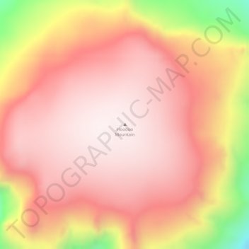
Naam: Topografische kaart Hoodoo Mountain, hoogte, reliëf.
Gemiddelde hoogte: 1.657 m
Minimale hoogte: 1.182 m
Maximale hoogte: 1.855 m
Doe een donatie
Rust jezelf uit voor je volgende avontuur:
Als Amazon-partner verdient deze site een commissie op in aanmerking komende aankopen, zonder extra kosten voor jou.
Andere topografische kaarten
Klik op een kaart om zijn topografie, zijn hoogte en zijn reliëf te bekijken.
Tumeka Lake
Canada > British Columbia > Regional District of Kitimat-Stikine > Area D (Iskut/Big Raven)
Gemiddelde hoogte: 1.382 m
Bob Quinn Lake
Canada > British Columbia > Regional District of Kitimat-Stikine > Area D (Iskut/Big Raven)
Gemiddelde hoogte: 585 m
Ball Creek
Canada > British Columbia > Regional District of Kitimat-Stikine > Area D (Iskut/Big Raven)
Gemiddelde hoogte: 1.228 m
Great Glacier
Canada > British Columbia > Regional District of Kitimat-Stikine > Area D (Iskut/Big Raven)
Gemiddelde hoogte: 866 m
Doe een donatie
Rust jezelf uit voor je volgende avontuur:
Als Amazon-partner verdient deze site een commissie op in aanmerking komende aankopen, zonder extra kosten voor jou.
Iskut River
Canada > British Columbia > Regional District of Kitimat-Stikine > Area D (Iskut/Big Raven)
Gemiddelde hoogte: 932 m