
Topografische kaart Trieste
Interactieve kaart
Klik op de kaart om de hoogte weer te geven.
Over deze kaart
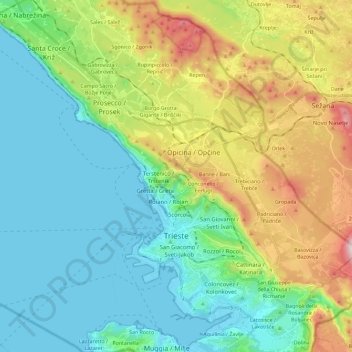
Naam: Topografische kaart Trieste, hoogte, reliëf.
Locatie: Trieste, Friuli-Venezia Giulia, 34121-34151, Italy (45.60680 13.66832 45.74662 13.89831)
Gemiddelde hoogte: 184 m
Minimale hoogte: -1 m
Maximale hoogte: 647 m
Trieste lies in the northernmost part of the high Adriatic in northeastern Italy, near the border with Slovenia. The city lies on the Gulf of Trieste. Built mostly on a hillside that becomes a mountain, Trieste's urban territory lies at the foot of an imposing escarpment that comes down abruptly from the Karst Plateau towards the sea. The karst hills delimiting the city reach an elevation of 458 metres (1,503 feet) above sea level. It lies at the junction point of the Italian geographical region, the Balkan Peninsula, and Mitteleuropan Area.
Andere topografische kaarten
Klik op een kaart om zijn topografie, zijn hoogte en zijn reliëf te bekijken.
Duino / Devin
Italy > Friuli-Venezia Giulia > Trieste > Duino Aurisina / Devin - Nabrežina
Duino / Devin, Duino Aurisina / Devin - Nabrežina, Trieste, Friuli-Venezia Giulia, 34011, Italy
Gemiddelde hoogte: 47 m
Dolina Seghina / Šeginov Dol
Italy > Friuli-Venezia Giulia > Trieste > Gabrovizza / Gabrovec > Stazione di Prosecco / Proseška Postaja
Dolina Seghina / Šeginov Dol, Stazione di Prosecco / Proseška Postaja, Gabrovizza / Gabrovec, Sgonico / Zgonik, Trieste, Friuli-Venezia Giulia, 34010, Italy
Gemiddelde hoogte: 249 m
Miramare / Miramar
Italy > Friuli-Venezia Giulia > Trieste > Trieste
Miramare / Miramar, Trieste, Friuli-Venezia Giulia, 34010, Italy
Gemiddelde hoogte: 106 m