
Doe een donatie
Rust jezelf uit voor je volgende avontuur:
Als Amazon-partner verdient deze site een commissie op in aanmerking komende aankopen, zonder extra kosten voor jou.
Topografische kaart Moscow
Klik op de kaart om de hoogte weer te geven.
Doe een donatie
Rust jezelf uit voor je volgende avontuur:
Als Amazon-partner verdient deze site een commissie op in aanmerking komende aankopen, zonder extra kosten voor jou.
Moscow
Along with the rest of the Idaho Panhandle, Moscow is in the Pacific Time Zone. The elevation of its city center is 2,579 feet (786 m) above sea level. Two major highways serve the city, passing through the city center: US-95 (north-south) and ID-8 (east-west). The Pullman–Moscow Regional Airport, four miles (6 km) west, provides limited commercial air service. The local newspaper is the Moscow-Pullman Daily News.
Doe een donatie
Rust jezelf uit voor je volgende avontuur:
Als Amazon-partner verdient deze site een commissie op in aanmerking komende aankopen, zonder extra kosten voor jou.
Over deze kaart
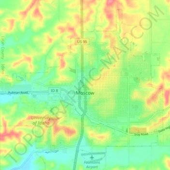
Naam: Topografische kaart Moscow, hoogte, reliëf.
Locatie: Moscow, Latah County, Idaho, United States (46.69870 -117.03988 46.75861 -116.96054)
Gemiddelde hoogte: 804 m
Minimale hoogte: 765 m
Maximale hoogte: 913 m
Doe een donatie
Rust jezelf uit voor je volgende avontuur:
Als Amazon-partner verdient deze site een commissie op in aanmerking komende aankopen, zonder extra kosten voor jou.
Andere topografische kaarten
Klik op een kaart om zijn topografie, zijn hoogte en zijn reliëf te bekijken.