
Topografische kaart Arak
Interactieve kaart
Klik op de kaart om de hoogte weer te geven.
Over deze kaart
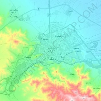
Naam: Topografische kaart Arak, hoogte, reliëf.
Locatie: Arak, بخش مرکزی, Arak County, Markazi Province, Iran (34.04294 49.60821 34.13117 49.79708)
Gemiddelde hoogte: 1.871 m
Minimale hoogte: 1.669 m
Maximale hoogte: 2.616 m
Arak is surrounded by mountains in the south, west, and east, and its average altitude is about 1750m above sea level. It is located 260 km from the city of Tehran, and is in the vicinity of the cities of Qom and Isfahan.
Andere topografische kaarten
Klik op een kaart om zijn topografie, zijn hoogte en zijn reliëf te bekijken.
شهرجرد
Iran > Markazi Province > Arak County > دهستان حاجی آباد
شهرجرد, دهستان حاجی آباد, بخش مرکزی, Arak County, Markazi Province, 38189-97985, Iran
Gemiddelde hoogte: 1.671 m