
Topografische kaart Thiruvalla
Interactieve kaart
Klik op de kaart om de hoogte weer te geven.
Over deze kaart
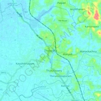
Naam: Topografische kaart Thiruvalla, hoogte, reliëf.
Locatie: Thiruvalla, Pathanamthitta, Kerala, 689111, India (9.34674 76.53627 9.42674 76.61627)
Gemiddelde hoogte: 10 m
Minimale hoogte: -1 m
Maximale hoogte: 74 m
Thiruvalla lies at an altitude of 9 meters above sea level on the basin of the Pamba and Manimala rivers. Thiruvalla is dotted with several natural canal streams (called "thodu" in Malayalam) like Chanthathodu, Manippuzha, Mullelithodu, and several others. The city area has riverine alluvial soil, and eastern parts have a laterite loam kind of soil classified under "Southern Midlands" agro-ecological zone, while the western suburbs like Niranam have a more sandy type of soil that resembles beaches. (Kuttanad agro-ecological zone)[7] The reason for this is believed to be the older status of Niranam as a port, before reclamation of Kuttanad from sea occurred. The Upper Kuttanad region in Thiruvalla has the "Karappadam" type of soil, which is clay loam in texture, has high organic matter, and is situated in areas about 1–2 m above sea level.[7]
Andere topografische kaarten
Klik op een kaart om zijn topografie, zijn hoogte en zijn reliëf te bekijken.
Parumala
India > Kerala > Thiruvalla
Parumala, Thiruvalla, Pathanamthitta District, Kerala, 689626, India
Gemiddelde hoogte: 6 m
Kumbanad
India > Kerala > Thiruvalla
Kumbanad, Thiruvalla, Pathanamthitta District, Kerala, 689547, India
Gemiddelde hoogte: 24 m
Purayidathilkavu
India > Kerala > Thiruvalla
Purayidathilkavu, Thiruvalla, Pathanamthitta District, Kerala, 689548, India
Gemiddelde hoogte: 36 m
Manackachira
India > Kerala > Thiruvalla > Eraviperoor
Manackachira, Eraviperoor, Thiruvalla, Pathanamthitta District, Kerala, 689541, India, Nellad
Gemiddelde hoogte: 12 m
Kaviyoor
India > Kerala > Thiruvalla > Kaniyanpara
Kaviyoor, Manackachira, Kaniyanpara, Thiruvalla, Pathanamthitta, Kerala, India
Gemiddelde hoogte: 15 m