
Topografische kaart Milton of Campsie
Interactieve kaart
Klik op de kaart om de hoogte weer te geven.
Over deze kaart
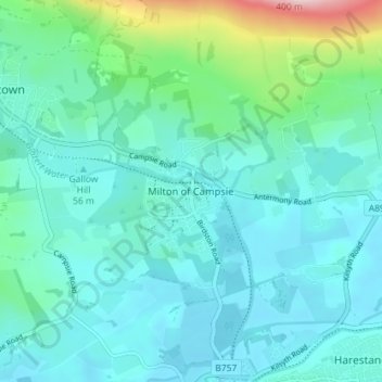
Naam: Topografische kaart Milton of Campsie, hoogte, reliëf.
Gemiddelde hoogte: 80 m
Minimale hoogte: 33 m
Maximale hoogte: 314 m
Andere topografische kaarten
Klik op een kaart om zijn topografie, zijn hoogte en zijn reliëf te bekijken.
Twechar
United Kingdom > Scotland > East Dunbartonshire
Twechar, East Dunbartonshire, Scotland, G65 9SA, United Kingdom
Gemiddelde hoogte: 64 m
Bearsden
United Kingdom > Scotland > East Dunbartonshire
Bearsden, East Dunbartonshire, Scotland, G61 3RU, United Kingdom
Gemiddelde hoogte: 72 m
Kirkintilloch
United Kingdom > Scotland > East Dunbartonshire
Kirkintilloch, East Dunbartonshire, Scotland, G66 1HF, United Kingdom
Gemiddelde hoogte: 68 m
Clachan of Campsie
United Kingdom > Scotland > East Dunbartonshire
Clachan of Campsie, East Dunbartonshire, Scotland, G66 7AB, United Kingdom
Gemiddelde hoogte: 226 m
Milngavie
United Kingdom > Scotland > East Dunbartonshire
Milngavie, East Dunbartonshire, Scotland, G62 6BH, United Kingdom
Gemiddelde hoogte: 99 m
Craigmaddie Reservoir
United Kingdom > Scotland > East Dunbartonshire > Milngavie
Craigmaddie Reservoir, Milngavie, East Dunbartonshire, Scotland, United Kingdom
Gemiddelde hoogte: 97 m
Fauldhead
United Kingdom > Scotland > East Dunbartonshire > Lenzie
Fauldhead, Lenzie, East Dunbartonshire, Scotland, United Kingdom
Gemiddelde hoogte: 62 m
Lenzie
United Kingdom > Scotland > East Dunbartonshire
Lenzie, East Dunbartonshire, Scotland, G66 5ER, United Kingdom
Gemiddelde hoogte: 68 m
Lennoxtown
United Kingdom > Scotland > East Dunbartonshire
Lennoxtown, East Dunbartonshire, Scotland, G66 7DB, United Kingdom
Gemiddelde hoogte: 199 m
Bishopbriggs
United Kingdom > Scotland > East Dunbartonshire
Bishopbriggs, East Dunbartonshire, Scotland, G64 2RA, United Kingdom
Gemiddelde hoogte: 60 m
Bardowie
United Kingdom > Scotland > East Dunbartonshire
Bardowie, East Dunbartonshire, Scotland, G62 6ES, United Kingdom
Gemiddelde hoogte: 58 m