
Topografische kaart Lympne
Interactieve kaart
Klik op de kaart om de hoogte weer te geven.
Over deze kaart
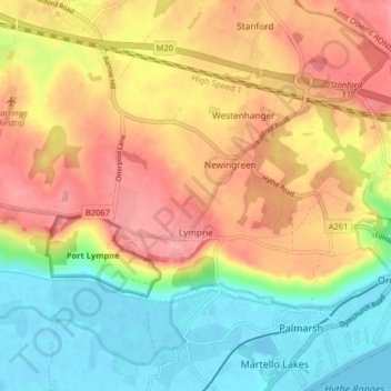
Naam: Topografische kaart Lympne, hoogte, reliëf.
Gemiddelde hoogte: 56 m
Minimale hoogte: -2 m
Maximale hoogte: 113 m
Andere topografische kaarten
Klik op een kaart om zijn topografie, zijn hoogte en zijn reliëf te bekijken.
Hythe
United Kingdom > England > Kent > Folkestone and Hythe District
Hythe, Folkestone and Hythe District, Kent, England, United Kingdom
Gemiddelde hoogte: 32 m
Folkestone
United Kingdom > England > Kent > Folkestone and Hythe District
Folkestone, Folkestone and Hythe District, Kent, England, United Kingdom
Gemiddelde hoogte: 62 m
Park Gate
United Kingdom > England > Kent > Folkestone and Hythe District > Elham
Park Gate, Elham, Folkestone and Hythe District, Kent, England, CT4 6BH, United Kingdom
Gemiddelde hoogte: 130 m
Littlestone on Sea
United Kingdom > England > Kent > Folkestone and Hythe District > New Romney
Littlestone on Sea, New Romney, Folkestone and Hythe District, Kent, England, TN28 8QU, United Kingdom
Gemiddelde hoogte: 1 m
Densole
United Kingdom > England > Kent > Folkestone and Hythe District
Densole, Folkestone and Hythe District, Kent, England, CT18 7BE, United Kingdom
Gemiddelde hoogte: 146 m