
Doe een donatie
Rust jezelf uit voor je volgende avontuur:
Als Amazon-partner verdient deze site een commissie op in aanmerking komende aankopen, zonder extra kosten voor jou.
Topografische kaart Austin
Klik op de kaart om de hoogte weer te geven.
Doe een donatie
Rust jezelf uit voor je volgende avontuur:
Als Amazon-partner verdient deze site een commissie op in aanmerking komende aankopen, zonder extra kosten voor jou.
Over deze kaart
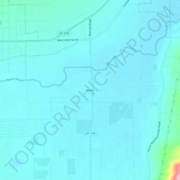
Naam: Topografische kaart Austin, hoogte, reliëf.
Locatie: Austin, Sevier County, Utah, 84724, United States (38.65219 -112.14159 38.69219 -112.10159)
Gemiddelde hoogte: 1.624 m
Minimale hoogte: 1.610 m
Maximale hoogte: 1.772 m
Doe een donatie
Rust jezelf uit voor je volgende avontuur:
Als Amazon-partner verdient deze site een commissie op in aanmerking komende aankopen, zonder extra kosten voor jou.
Andere topografische kaarten
Klik op een kaart om zijn topografie, zijn hoogte en zijn reliëf te bekijken.
Richfield
United States > Utah > Sevier County
Richfield experiences a cold semi-arid climate (Köppen BSk) with four distinct seasons. Winter high temperatures average in the 30s and 40s with many milder days; low temperatures average in the teens and twenties, with a few mornings starting near or below zero. Snowfall is common, but usually melts in a day…
Gemiddelde hoogte: 1.659 m
Fish Lake
United States > Utah > Sevier County
Fish Lake is a high alpine lake (elevation approximately 8,848 ft or 2,700 m) located in the Fishlake/ Southern Wasatch Plateau region of south-central Utah, United States. It lies within and is the namesake of the Fishlake National Forest.
Gemiddelde hoogte: 2.886 m
Doe een donatie
Rust jezelf uit voor je volgende avontuur:
Als Amazon-partner verdient deze site een commissie op in aanmerking komende aankopen, zonder extra kosten voor jou.
Richfield
United States > Utah > Sevier County
Richfield experiences a cold semi-arid climate (Köppen BSk) with four distinct seasons. Winter high temperatures average in the 30s and 40s with many milder days; low temperatures average in the teens and twenties, with a few mornings starting near or below zero. Snowfall is common, but usually melts in a day…
Gemiddelde hoogte: 1.659 m