
Topografische kaart Litchfield
Interactieve kaart
Klik op de kaart om de hoogte weer te geven.
Over deze kaart
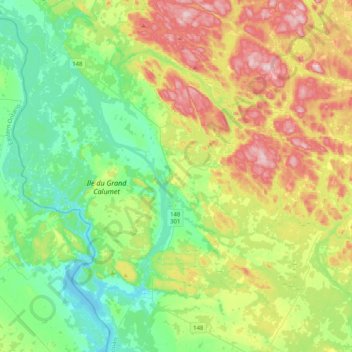
Naam: Topografische kaart Litchfield, hoogte, reliëf.
Gemiddelde hoogte: 174 m
Minimale hoogte: 85 m
Maximale hoogte: 341 m
Andere topografische kaarten
Klik op een kaart om zijn topografie, zijn hoogte en zijn reliëf te bekijken.
Lac Clark
Canada > Quebec > Pontiac (MRC) > Otter Lake
Lac Clark, Otter Lake, Pontiac (MRC), Outaouais, Quebec, Canada
Gemiddelde hoogte: 235 m
Klukeville
Canada > Quebec > Pontiac (MRC) > Otter Lake
Klukeville, Otter Lake, Pontiac (MRC), Outaouais, Quebec, Canada
Gemiddelde hoogte: 277 m
Chapeau
Canada > Quebec > Pontiac (MRC) > L'Isle-aux-Allumettes > Chapeau
Chapeau, L'Isle-aux-Allumettes, Pontiac (MRC), Outaouais, Quebec, J0X 1M0, Canada
Gemiddelde hoogte: 139 m
Shawville
Canada > Quebec > Pontiac (MRC)
Shawville, Pontiac (MRC), Outaouais, Quebec, J0X 2Y0, Canada
Gemiddelde hoogte: 171 m
Chichester
Canada > Quebec > Pontiac (MRC)
Chichester, Pontiac (MRC), Outaouais, Quebec, Canada
Gemiddelde hoogte: 239 m
Jim Lake
Canada > Quebec > Pontiac (MRC) > Mansfield-et-Pontefract
Jim Lake, Mansfield-et-Pontefract, Pontiac (MRC), Outaouais, Quebec, Canada
Gemiddelde hoogte: 241 m
Lac Hodgins
Canada > Quebec > Pontiac (MRC) > Clarendon
Lac Hodgins, Clarendon, Pontiac (MRC), Outaouais, Quebec, Canada
Gemiddelde hoogte: 205 m
Ladysmith
Canada > Quebec > Pontiac (MRC) > Thorne
Ladysmith, Thorne, Pontiac (MRC), Outaouais, Quebec, J0X 2A0, Canada
Gemiddelde hoogte: 222 m
Campbell's Bay
Canada > Quebec > Pontiac (MRC)
Campbell's Bay, Pontiac (MRC), Outaouais, Quebec, J0X 1K0, Canada
Gemiddelde hoogte: 128 m